
A Winter Storm Watch remains in effect for MoCo from 1pm on Sunday, January 16th until 7am Monday, January 17th.
Right now it looks like snow will move into the area in the afternoon hours and continue into the evening before changing over to ice and eventually rain. Since the ground will be cold from temperatures that’ll likely remain below 30° until early Monday morning when temps can reach the mid to upper 30s. Sunday evening should be a mess and it may carry over into Monday morning.
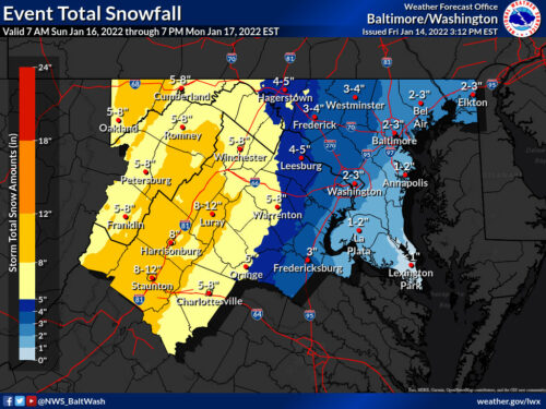
Below you’ll see a compilation of some of the weather maps released by local news outlets, but first let’s take a look at the latest map from the National Weather Service (the latest map came out at 3:12pm, so we’ll have an updated map in the morning). Almost all of MoCo is looking at 3-4” before switching over to ice and then rain.
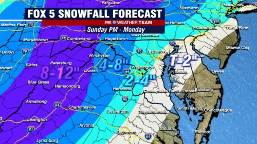
Fox 5 dropped totals to 2-4” for almost all of MoCo.
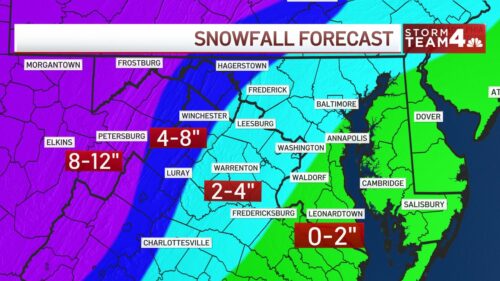
NBC4 has all of MoCo in the 2-4” range.
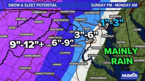
WUSA9 (CBS) has MoCo in the 3-6” range.
We haven’t been able to find a map from WJLA (ABC7 yet), but we hope to be able to share one tomorrow.
Below you’ll see the “forecaster‘s discussion” from the National Weather Service:
“Winter Storm Watches were expanded to include portions of the I-95 corridor near the Baltimore/Washington metro where confidence of an impactful winter event is increasing.
Winter Storm Watches remain in place for the previously issued locations. Only change to the previously issued Winter Storm Watch was to extend the timing of the far western segment along the Allegheny Front until 12 PM Monday to account for wrap around snow showers and orographic lift as the ULL moves to the northeast.
This is a complex forecast with multiple precipitation types forecast across the region. Overall QPF amounts will be on the order of an inch to an inch and a half, with the highest amounts currently forecast along the Blue Ridge. There will be a local minima in QPF/snowfall amounts just west of the Blue Ridge Mountains due to downsloping and just west of the ridges from Allegany County, MD down to Augusta County, VA. The eastern facing sides of the Allegheny Mountains may see the highest snowfall amounts prior to the ULL and surface low moving north of the region, when the western facing slopes of the Alleghenies see a period of snow into midday Monday.
Uncertainty remains high regarding precipitation type east of I-81, especially near/along the I-95 corridor. The ultimate track and strength of the surface, 850 mb, and ULL low will determine the difference between an inch or two of snow and potentially six inches of snow over a narrow (20-30) km area.
A stronger low will also result in a stronger U-wind component and WAA resulting in the potential for more sleet, along with freezing rain or plain rain. The zones with the best opportunity for all snow are west of I-81. Icing accumulations will be noteworthy across the region where icing sets up.
Currently thinking any heavier icing would be between I-81 and US-15. Where the snow and sleet does change to plain rain, there is the possibility for minor flooding (mainly along/near I-95 and east).
The winds will also be impressive throughout the storm, with the peak winds expected just east of the low and strongest winds areawide as the low pulls off to the north. Wind gusts of 45+ mph are possible along the higher terrain of the Allegheny Front and Blue Ridge. This could result in blizzard conditions. Wind headlines may be needed elsewhere.
Regarding snowfall accumulations near the I-95 corridor, there is the potential for a several hour thump of snow with rates close to an inch or two per hour. While the total accumulations may come short of warning criteria, these rates could be impactful nonetheless.”
Recent Stories
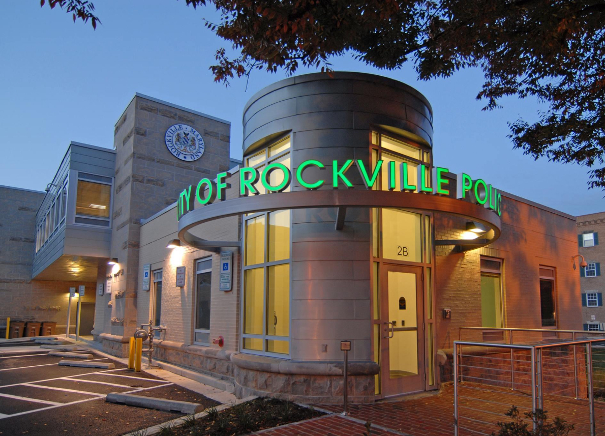
Rockville City Police put out a message on social media warning the public of a new scam that’s occurring locally via phone that involves scammers posing as fire inspectors and…
In December 2022, we let you know that Dunkin’ is continuing its massive expansion across the country and in MoCo, with an upcoming location coming to the Traville Village Center…
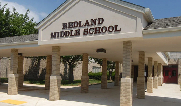
March Madness took on a new dimension this year as 16 middle schools engaged in their own version of the tournament: March MATHness, MCPS announced in its staff bulletin. The…
Montgomery County Public Schools (MCPS) released the following statement concerning the arrest of a student from Thomas S. Wootton High School in Rockville:
17th Annual Kensington Day of the Book Festival

Now in its 17th year, the Kensington Day of the Book Festival is a family-friendly street festival featuring 150+ renowned authors, poets, and literary organizations. Enjoy live music on five stages, special guest speakers, military veteran writers and comedians, poetry readings, cookbook demos, children's program, and much more.
Admission is free, and attendees will also be able to explore a marketplace of books and food offerings from local vendors.
Not your average book festival! This festival offers something for everyone!
17th Annual Kensington Day of the Book Festival
Sunday, April 21, 2024, 11am-4pm (held rain or shine!)
Howard Avenue, Kensington, MD 20895
www.dayofthebook.com
Instagram: @kensingtonbookfestival
Contact: Elisenda Sola-Sole, Festival Director
301-949-9416 (text preferred)
FEST OF SPRING Caribbean Wine Food & Music Festival

Get ready to experience the vibrant colors, tantalizing flavors, and infectious rhythms of the Caribbean at the FEST OF SPRING Caribbean Wine Food & Music Festival! Hosted by RHU LLC, this exciting festival is set to take place on May 18, 2024, at the picturesque 16700 Barnesville Rd in Boyds, MD.
Step into a world where the Caribbean spirit comes alive! From 12:00 PM onwards, immerse yourself in a sensory journey that celebrates the unique culture, cuisine, and music of the Caribbean. Whether you're an African American, a Reggae or Soca music enthusiast, a wine lover, or part of the vibrant Caribbean diaspora, this festival promises to delight and captivate you in every way.
Let the enticing aromas of mouthwatering Caribbean dishes tantalize your taste buds. Feast on traditional delicacies prepared by expert chefs, showcasing the rich and diverse culinary heritage of the Caribbean. Indulge in flavorful jerk chicken, succulent seafood, and delectable plantain dishes that will transport you straight to the islands.
Accompanying the culinary extravaganza is a carefully curated selection of premium wines, ensuring the perfect pairing for your palate. Sip on fine wines from renowned vineyards, each sip a reflection of the Caribbean's vibrant spirit. Discover new flavors, expand your wine knowledge, and savor unforgettable moments with every glass.
As the sun sets, get ready to groove to the infectious rhythms of Caribbean music. Feel the pulsating beats of reggae, soca, dancehall, and calypso, moving your body to the lively melodies. Live performances by talented musicians and performers will keep the energy high, ensuring a night of unforgettable entertainment.
Don't miss this opportunity to embrace the Caribbean spirit and celebrate the arrival of spring in style! Tickets are available on AllEvents, so secure your spot today. Join us at the FEST OF SPRING Caribbean Wine Food & Music Festival, where cultures collide and unforgettable memories are made.
LIVE PERFORMANCES By: CULTURE Feat. Kenyatta Hill, EXCO LEVI, IMAGE BAND, RAS LIDJ REGG'GO with Special Guest SUGAR BEAR FROM E.U. & MORE! & MORE!
MUSIC By: DJ ABLAZE, DJ SMALLY & NAJ SUPREME
2 NIGHT Camping packages available: RV/CAMPER $200 | TENTS $150 Starting on Friday May 17 @ 5pm | 30 RV SPACES | 30+ TENT SPACES
KIDS 12 & UNDER FREE!!!