
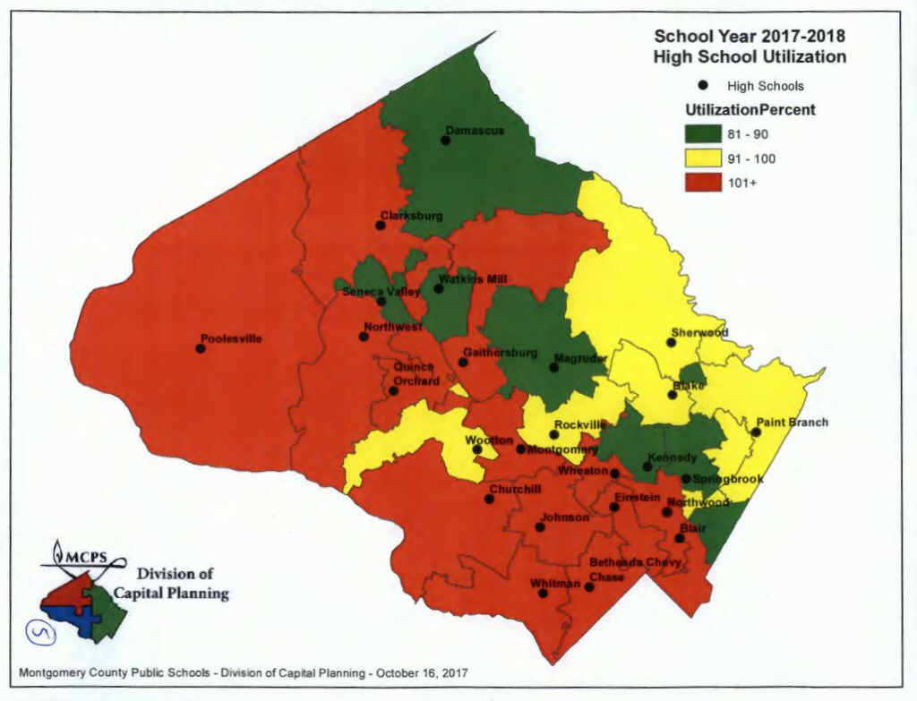
The map above shows the boundaries and utilization figures at each MoCo high school.
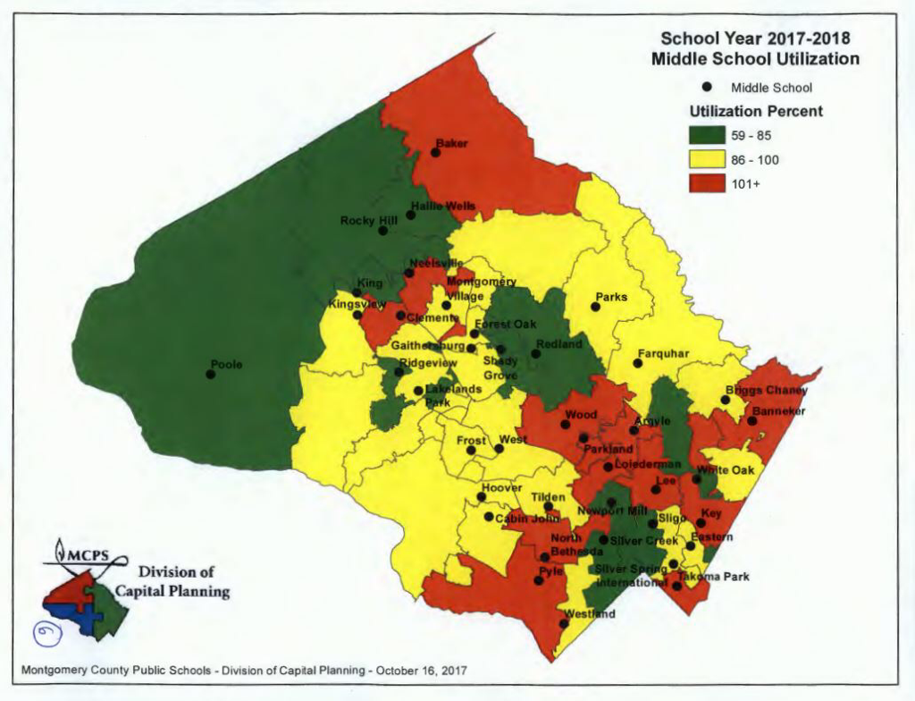
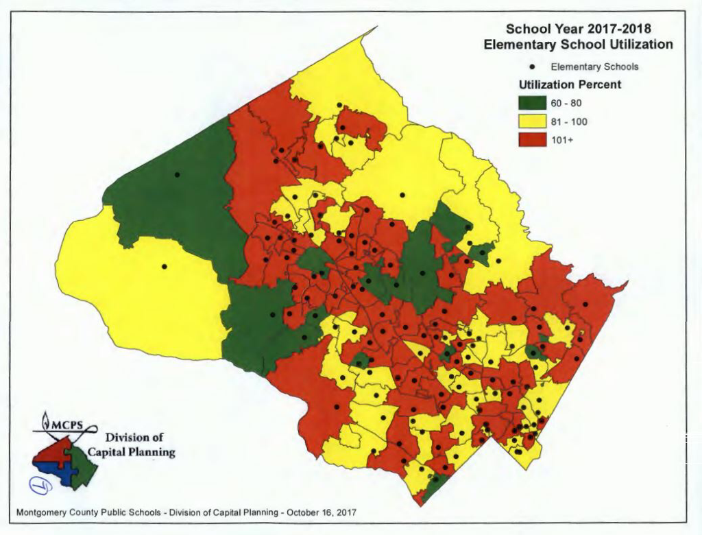
Below you will see the same types of maps for middle and elementary schools.
Based on the maps, a change to some of these boundaries could make sense in terms of balancing utilization, but opens up a different can of worms in regards to property value.
Recent Stories

A group of MCPS students have come together to spread awareness about the impact of bullying, harassment and hate-bias. This student-led video campaign is part of the ongoing work to…
The Montgomery County Department of Transportation (MCDOT) has announced that it will offer free rides on Ride On, Ride On extRa, Ride On flex and Flash on Monday, April 22,…
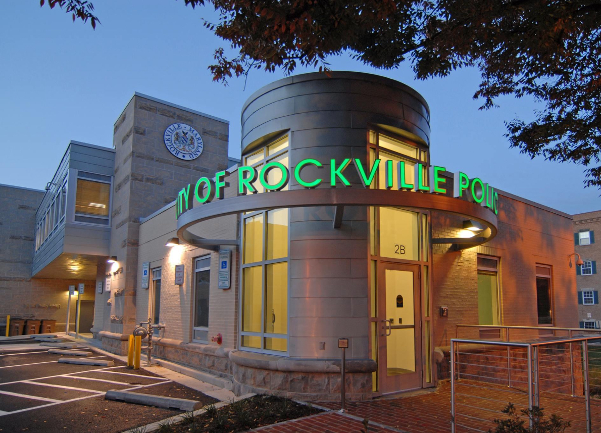
The Rockville City Police Department’s Chief Victor V. Brito recently shared a crime report/data with Rockville Mayor and Council showing reduced crime rates in 2023. According to a press release…

Montgomery County Police are searching for a suspect involved in an auto theft that occurred last month in Rockville.
17th Annual Kensington Day of the Book Festival
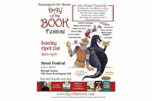
Now in its 17th year, the Kensington Day of the Book Festival is a family-friendly street festival featuring 150+ renowned authors, poets, and literary organizations. Enjoy live music on five stages, special guest speakers, military veteran writers and comedians, poetry readings, cookbook demos, children's program, and much more.
Admission is free, and attendees will also be able to explore a marketplace of books and food offerings from local vendors.
Not your average book festival! This festival offers something for everyone!
17th Annual Kensington Day of the Book Festival
Sunday, April 21, 2024, 11am-4pm (held rain or shine!)
Howard Avenue, Kensington, MD 20895
www.dayofthebook.com
Instagram: @kensingtonbookfestival
Contact: Elisenda Sola-Sole, Festival Director
301-949-9416 (text preferred)
FEST OF SPRING Caribbean Wine Food & Music Festival

Get ready to experience the vibrant colors, tantalizing flavors, and infectious rhythms of the Caribbean at the FEST OF SPRING Caribbean Wine Food & Music Festival! Hosted by RHU LLC, this exciting festival is set to take place on May 18, 2024, at the picturesque 16700 Barnesville Rd in Boyds, MD.
Step into a world where the Caribbean spirit comes alive! From 12:00 PM onwards, immerse yourself in a sensory journey that celebrates the unique culture, cuisine, and music of the Caribbean. Whether you're an African American, a Reggae or Soca music enthusiast, a wine lover, or part of the vibrant Caribbean diaspora, this festival promises to delight and captivate you in every way.
Let the enticing aromas of mouthwatering Caribbean dishes tantalize your taste buds. Feast on traditional delicacies prepared by expert chefs, showcasing the rich and diverse culinary heritage of the Caribbean. Indulge in flavorful jerk chicken, succulent seafood, and delectable plantain dishes that will transport you straight to the islands.
Accompanying the culinary extravaganza is a carefully curated selection of premium wines, ensuring the perfect pairing for your palate. Sip on fine wines from renowned vineyards, each sip a reflection of the Caribbean's vibrant spirit. Discover new flavors, expand your wine knowledge, and savor unforgettable moments with every glass.
As the sun sets, get ready to groove to the infectious rhythms of Caribbean music. Feel the pulsating beats of reggae, soca, dancehall, and calypso, moving your body to the lively melodies. Live performances by talented musicians and performers will keep the energy high, ensuring a night of unforgettable entertainment.
Don't miss this opportunity to embrace the Caribbean spirit and celebrate the arrival of spring in style! Tickets are available on AllEvents, so secure your spot today. Join us at the FEST OF SPRING Caribbean Wine Food & Music Festival, where cultures collide and unforgettable memories are made.
LIVE PERFORMANCES By: CULTURE Feat. Kenyatta Hill, EXCO LEVI, IMAGE BAND, RAS LIDJ REGG'GO with Special Guest SUGAR BEAR FROM E.U. & MORE! & MORE!
MUSIC By: DJ ABLAZE, DJ SMALLY & NAJ SUPREME
2 NIGHT Camping packages available: RV/CAMPER $200 | TENTS $150 Starting on Friday May 17 @ 5pm | 30 RV SPACES | 30+ TENT SPACES
KIDS 12 & UNDER FREE!!!