
Overnight Model Output Gives Our Area Significant Snowfall
Fox 5’s Mike Thomas has been providing the play by play for this one, sharing the amount of snow the GFS (American model) and Euro (European model) are showing for our area this Thursday, 2/18.
Below is the progression from the GFS from Monday morning to Monday evening to this morning.
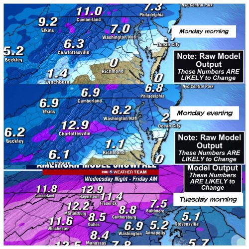
You can see that it has been fairly consistent showing snow in the 7-9” range, but we know that can change.
We also want to share the Euro from Monday morning, Monday evening, and this morning.
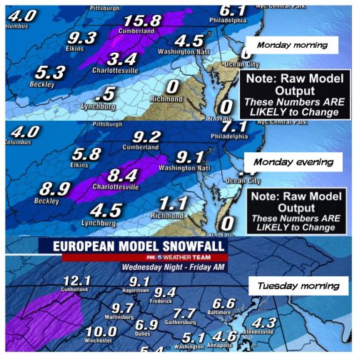
You can see that it went from 4.5” to about twice that amount and then back down to 7.7”
This goes to show you quickly things can change and most meteorologists are simply sharing the data they have while consistently warning that the numbers will likely change.
To reference the sports analogy again, they can only tell you what the score is as the game is happening.
The score at the end of the 1st quarter isn’t the final score.
Based on how the season is going, you can have a hunch on what will happen, but the best thing to do is follow along and root for whatever you’d like to see knowing it may not happen.
We’ll have an update later today that will include the latest GFS and Euro runs.
Recent Stories
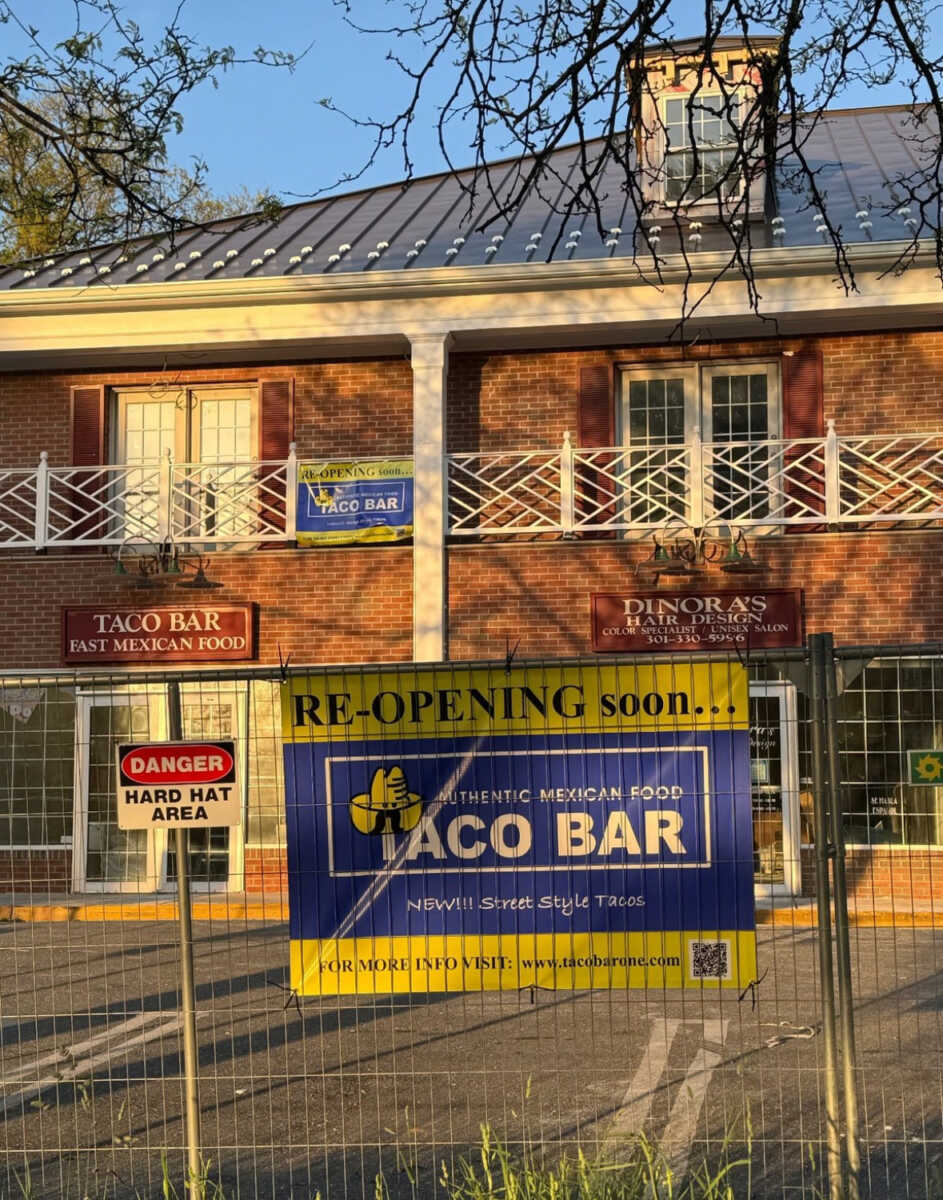
“Re-opening Soon” signage is up at Taco Bar (3 Russell Ave) in Olde Towne Gaithersburg. The restaurant was forced to close following a fire, which was part of an arson spree…
Germantown’s SkyPoint Federal Credit Union (SkyPoint), a community-based financial institution “who makes banking simple and accessible” announced that they will be featured on season two of the award-winning reality TV series, Opportunity…
Cloud 9 Nail Lounge, a salon that will offer the opportunity to enjoy an alcoholic beverage during your mani/pedi, will hold its grand opening at 20940-E Frederick Rd in the…

The Montgomery County Department of Transportation (MCDOT) has published a list of bus routes available for residents to access Montgomery County’s 14 early voting centers for the upcoming presidential primary.
FEST OF SPRING Caribbean Wine Food & Music Festival

Get ready to experience the vibrant colors, tantalizing flavors, and infectious rhythms of the Caribbean at the FEST OF SPRING Caribbean Wine Food & Music Festival! Hosted by RHU LLC, this exciting festival is set to take place on May 18, 2024, at the picturesque 16700 Barnesville Rd in Boyds, MD.
Step into a world where the Caribbean spirit comes alive! From 12:00 PM onwards, immerse yourself in a sensory journey that celebrates the unique culture, cuisine, and music of the Caribbean. Whether you're an African American, a Reggae or Soca music enthusiast, a wine lover, or part of the vibrant Caribbean diaspora, this festival promises to delight and captivate you in every way.
Let the enticing aromas of mouthwatering Caribbean dishes tantalize your taste buds. Feast on traditional delicacies prepared by expert chefs, showcasing the rich and diverse culinary heritage of the Caribbean. Indulge in flavorful jerk chicken, succulent seafood, and delectable plantain dishes that will transport you straight to the islands.
Accompanying the culinary extravaganza is a carefully curated selection of premium wines, ensuring the perfect pairing for your palate. Sip on fine wines from renowned vineyards, each sip a reflection of the Caribbean's vibrant spirit. Discover new flavors, expand your wine knowledge, and savor unforgettable moments with every glass.
As the sun sets, get ready to groove to the infectious rhythms of Caribbean music. Feel the pulsating beats of reggae, soca, dancehall, and calypso, moving your body to the lively melodies. Live performances by talented musicians and performers will keep the energy high, ensuring a night of unforgettable entertainment.
Don't miss this opportunity to embrace the Caribbean spirit and celebrate the arrival of spring in style! Tickets are available on AllEvents, so secure your spot today. Join us at the FEST OF SPRING Caribbean Wine Food & Music Festival, where cultures collide and unforgettable memories are made.
LIVE PERFORMANCES By: CULTURE Feat. Kenyatta Hill, EXCO LEVI, IMAGE BAND, RAS LIDJ REGG'GO with Special Guest SUGAR BEAR FROM E.U. & MORE! & MORE!
MUSIC By: DJ ABLAZE, DJ SMALLY & NAJ SUPREME
2 NIGHT Camping packages available: RV/CAMPER $200 | TENTS $150 Starting on Friday May 17 @ 5pm | 30 RV SPACES | 30+ TENT SPACES
KIDS 12 & UNDER FREE!!!