
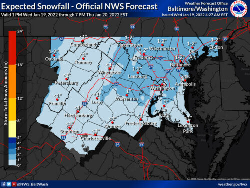
The National Weather Service updated its maps overnight, increasing potential snow totals for most of the area.
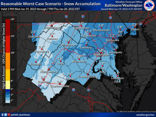
Per the maps, all of MoCo is in the 1-2” range for snowfall tomorrow morning. The “reasonable worst case scenario” map is now at just about 2 inches so confidence is increasing for 1-2” all around.
Chuck Bell of NBC4 also tweeted that his confidence in at least an inch has increased to 80% with a 30% chance of getting over 2 inches and just a 5% chance at over 3 inches.
Just updated. My confidence in most of the DC Metro area getting an inch of snow between 5-9am Thursday has increased. I also moved up the chances for 2" of snow from 20% to 30%, and lowered the chances of anyone getting more than 3". A slow, slushy slog of an AM commute for sure pic.twitter.com/idthSk3ant
— Chuck Bell (@ChuckBell4) January 19, 2022
The rain has dried out a bit in some models, so we’re going to wait for the short range models later today to see if we’ll be getting rain then a switch over to snow or just snow in the morning.
Highs today will be in the mid 40s and it could be the last time in a week or two that we reach 40° as cold is expected for a while after this.
If the rain does come through, we expect it to start around 2am or so and the changeover to snow to occur between 5am and 7am. Initially this will only make roads wet, but enough snow could lead to snow sticking and the timing during the morning rush does not help with anyone’s commute. Snow should be out of the area by late morning.
We’ll have additional updates throughout the day.
Recent Stories
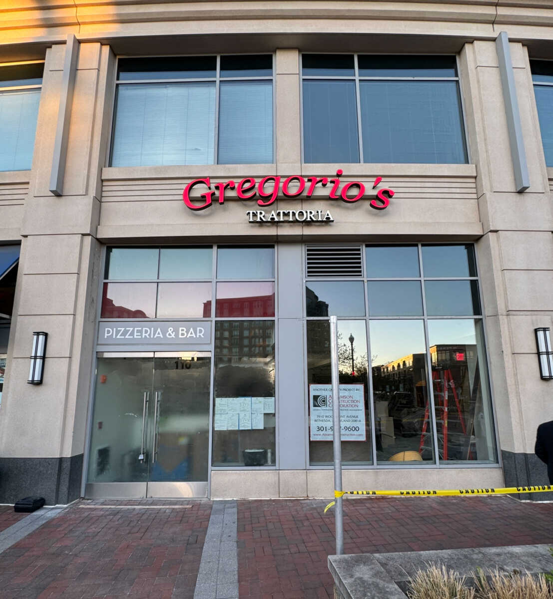
In September 2021, we let you know that Gregorio’s Trattoria would be opening its third MoCo location, and fourth overall, at Park Potomac- taking over the space that was previously…
Montgomery County Public Schools (MCPS) issued the following community message on Monday, April 15, regarding the proposed self-service bus tracking app.
The Montgomery County Council will meet on Tuesday, April 16 at 9am to continue their review of the FY25-30 Capital Improvements Program. There will then be a joint committee meeting…

Montgomery County Fire and Rescue Services (MCFRS) responded to the 400blk of Green Pasture Dr in Rockville for the report of a fire on Monday, April 15.
17th Annual Kensington Day of the Book Festival
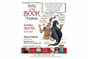
Now in its 17th year, the Kensington Day of the Book Festival is a family-friendly street festival featuring 150+ renowned authors, poets, and literary organizations. Enjoy live music on five stages, special guest speakers, military veteran writers and comedians, poetry readings, cookbook demos, children's program, and much more.
Admission is free, and attendees will also be able to explore a marketplace of books and food offerings from local vendors.
Not your average book festival! This festival offers something for everyone!
17th Annual Kensington Day of the Book Festival
Sunday, April 21, 2024, 11am-4pm (held rain or shine!)
Howard Avenue, Kensington, MD 20895
www.dayofthebook.com
Instagram: @kensingtonbookfestival
Contact: Elisenda Sola-Sole, Festival Director
301-949-9416 (text preferred)
FEST OF SPRING Caribbean Wine Food & Music Festival

Get ready to experience the vibrant colors, tantalizing flavors, and infectious rhythms of the Caribbean at the FEST OF SPRING Caribbean Wine Food & Music Festival! Hosted by RHU LLC, this exciting festival is set to take place on May 18, 2024, at the picturesque 16700 Barnesville Rd in Boyds, MD.
Step into a world where the Caribbean spirit comes alive! From 12:00 PM onwards, immerse yourself in a sensory journey that celebrates the unique culture, cuisine, and music of the Caribbean. Whether you're an African American, a Reggae or Soca music enthusiast, a wine lover, or part of the vibrant Caribbean diaspora, this festival promises to delight and captivate you in every way.
Let the enticing aromas of mouthwatering Caribbean dishes tantalize your taste buds. Feast on traditional delicacies prepared by expert chefs, showcasing the rich and diverse culinary heritage of the Caribbean. Indulge in flavorful jerk chicken, succulent seafood, and delectable plantain dishes that will transport you straight to the islands.
Accompanying the culinary extravaganza is a carefully curated selection of premium wines, ensuring the perfect pairing for your palate. Sip on fine wines from renowned vineyards, each sip a reflection of the Caribbean's vibrant spirit. Discover new flavors, expand your wine knowledge, and savor unforgettable moments with every glass.
As the sun sets, get ready to groove to the infectious rhythms of Caribbean music. Feel the pulsating beats of reggae, soca, dancehall, and calypso, moving your body to the lively melodies. Live performances by talented musicians and performers will keep the energy high, ensuring a night of unforgettable entertainment.
Don't miss this opportunity to embrace the Caribbean spirit and celebrate the arrival of spring in style! Tickets are available on AllEvents, so secure your spot today. Join us at the FEST OF SPRING Caribbean Wine Food & Music Festival, where cultures collide and unforgettable memories are made.
LIVE PERFORMANCES By: CULTURE Feat. Kenyatta Hill, EXCO LEVI, IMAGE BAND, RAS LIDJ REGG'GO with Special Guest SUGAR BEAR FROM E.U. & MORE! & MORE!
MUSIC By: DJ ABLAZE, DJ SMALLY & NAJ SUPREME
2 NIGHT Camping packages available: RV/CAMPER $200 | TENTS $150 Starting on Friday May 17 @ 5pm | 30 RV SPACES | 30+ TENT SPACES
KIDS 12 & UNDER FREE!!!