
Snow Potential Sunday into Early Next Week
You may have heard the buzz…we can confirm that there’s potential for a significant storm Sunday into early next week, but we are still far out enough for many things to change.
This is one of those “I’ll believe it when I see it” situations, which is pretty much every storm if you’re familiar with out area.
Here’s how things are looking:
Both the Euro (European model) and the GFS (American model) are showing potential for a significant storm.
We’re not talking totals yet because they’ve fluctuated in a major way in the last three runs of the Euro, so throwing any number out right now wouldn’t be a good idea, but we can reiterate that the potential for a significant storm is there.
If this occurs a Sunday start is likely, but then a lot depends on what it becomes…
Will it be a coastal storm that brings snow through Monday and into Tuesday? That would obviously lead to much higher totals.
Could it be another swing and a miss that barely brings snow to our area? That’s also on the table.
It could also be a moderate event that brings a few inches to our area and makes things difficult for us for a few hours.
We’ve seen places sharing snow totals from one run of one model, but you have to remember just that…it’s only one run from one model.
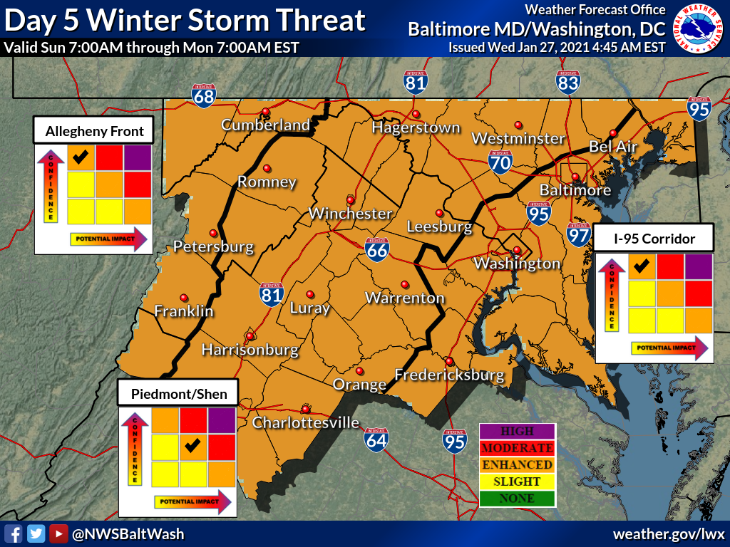
Our featured photo from the National Weather Service shows that currently have a high level of confidence for an enhanced winter storm threat.
Things will start to look a little clearer as we reach the start of the weekend and we’ll keep you updated!
Recent Stories
According to the Montgomery County State’s Attorney’s Office, “in the Circuit Court for Montgomery County, MD, before the Honorable Margaret Schweitzer, a jury found defendant, Geofrey Gaitan, 31, of Silver…

MCPS High School Sports Scores for Apr 24, 2024 (powered by www.MoCoAI.com):

The State Board voted unanimously on April 24, 2024, to appoint Dr. Carey M. Wright as the Maryland State Superintendent of Schools for the term to begin July 1, 2024….
Montgomery County Police are investigating an attempted sexual assault that occurred on Tuesday, April 23.
FEST OF SPRING Caribbean Wine Food & Music Festival

Get ready to experience the vibrant colors, tantalizing flavors, and infectious rhythms of the Caribbean at the FEST OF SPRING Caribbean Wine Food & Music Festival! Hosted by RHU LLC, this exciting festival is set to take place on May 18, 2024, at the picturesque 16700 Barnesville Rd in Boyds, MD.
Step into a world where the Caribbean spirit comes alive! From 12:00 PM onwards, immerse yourself in a sensory journey that celebrates the unique culture, cuisine, and music of the Caribbean. Whether you're an African American, a Reggae or Soca music enthusiast, a wine lover, or part of the vibrant Caribbean diaspora, this festival promises to delight and captivate you in every way.
Let the enticing aromas of mouthwatering Caribbean dishes tantalize your taste buds. Feast on traditional delicacies prepared by expert chefs, showcasing the rich and diverse culinary heritage of the Caribbean. Indulge in flavorful jerk chicken, succulent seafood, and delectable plantain dishes that will transport you straight to the islands.
Accompanying the culinary extravaganza is a carefully curated selection of premium wines, ensuring the perfect pairing for your palate. Sip on fine wines from renowned vineyards, each sip a reflection of the Caribbean's vibrant spirit. Discover new flavors, expand your wine knowledge, and savor unforgettable moments with every glass.
As the sun sets, get ready to groove to the infectious rhythms of Caribbean music. Feel the pulsating beats of reggae, soca, dancehall, and calypso, moving your body to the lively melodies. Live performances by talented musicians and performers will keep the energy high, ensuring a night of unforgettable entertainment.
Don't miss this opportunity to embrace the Caribbean spirit and celebrate the arrival of spring in style! Tickets are available on AllEvents, so secure your spot today. Join us at the FEST OF SPRING Caribbean Wine Food & Music Festival, where cultures collide and unforgettable memories are made.
LIVE PERFORMANCES By: CULTURE Feat. Kenyatta Hill, EXCO LEVI, IMAGE BAND, RAS LIDJ REGG'GO with Special Guest SUGAR BEAR FROM E.U. & MORE! & MORE!
MUSIC By: DJ ABLAZE, DJ SMALLY & NAJ SUPREME
2 NIGHT Camping packages available: RV/CAMPER $200 | TENTS $150 Starting on Friday May 17 @ 5pm | 30 RV SPACES | 30+ TENT SPACES
KIDS 12 & UNDER FREE!!!