
By Mark Walston
Courtesy of the Bethesda Historical Society
Advances in transportation over the course of two centuries transformed Bethesda from a rural wayside stop into a bustling metropolis. But for much of its early existence, Bethesda was little more than “a wide spot in the road,” as one early resident put it.
That road (today’s Wisconsin Avenue and Old Georgetown Road) began in the far past as a ridgeline trail through ancient woods, carrying the first settlers, the Native Americans, as they hunted game in the land among the Potomac, Patuxent, and Monocacy Rivers. At the end of the 17th century it brought Dutch fur traders, who built a one-story granite trading post dominated by a great stone chimney rising up through the middle of the roof (part of which still stands) near the intersection of present-day River Road and Little Falls Parkway.
It also brought the English to newly granted plantations measured out of the virgin forests. In time, farmers hauled produce over the road, sacks of wheat and big, rolling hogsheads of tobacco destined for the nascent 18th-century port of Georgetown. Drovers herded livestock, British regiments marched in formation, and travelers joggled along the dirt road in wheeled wagons.
By the middle of the 18th century a small stone tavern had been built near a bend in the road, offering respite and replenishment to passersby. Situated near the northwest intersection of present-day Old Georgetown Road and Wisconsin Avenue, the “old stone tavern,” as it was familiarly called, was the first commercial establishment in the area—and the nucleus of what would become downtown Bethesda.
Bethesda’s early status as a wayside stop was commemorated in 1929 by the Daughters of the American Revolution, who erected their “Madonna of the Trail” statue honoring not those who stayed, but those who passed through. The 10-foot statue, sculpted by German-born artist August Leimbach and depicting a pioneer mother cradling a small child while another clings to her skirt, was one of 12 identical monuments placed along a route between Bethesda and Upland, Calif., commemorating women’s contributions to America’s westward movement. (Today, it seems as if the mother, her face set with a rugged determination, is leaning forward in nervous anticipation as she and her children prepare for the harrowing task of crossing Wisconsin Avenue at rush hour.)
By the early 19th century, the old road had fallen into disrepair, and in 1805, the Maryland legislature chartered a new company dedicated to improving the road between the District line and Rockville, the county seat. Work languished until the company was rechartered in 1817. Within a few years, the new turnpike opened, the first hard- surfaced road in the county, a 20-foot-wide strip veering off from the older Georgetown road near the stone tavern to run in a straight line to Rockville. The vision was to extend the pike to Frederick and beyond. A small, wooden tollbooth appeared south of the intersection, collecting fees from travelers—12½ cents for a score of sheep or hogs, 6¼ cents for every horse and rider, 25 cents for a coach or stage with two horses and four wheels—with the money divided among stockholders of the turnpike and, ostensibly, invested in the road’s maintenance.
Here and there near the new intersection, houses were built, modest affairs, simple clapboard homes of yeoman farmers fronting open fields of grazing cattle and rolling hills of wheat and corn.
In the 19th Century, Post Offices were frequently named for their postmasters or the establishments in which they were located. So when, in 1852, a Post Office was established in or near the local Presbyterian meeting house that still stands a couple of miles north of the intersection, high on a hill above the pike, it was called “Bethesda” after the meeting house, itself named for the miraculous Pool of Bethesda in Jerusalem. (To be fair, the area began to be known by that name not long after the church opened, in 1820). Not surprisingly, the church pastor was the first postmaster, but notwithstanding its ecclesiastical support the Post Office (though not the church) closed within six months.
Ten years later the federal government again deemed the area around the somnambulant crossroads sufficiently populated to warrant a post office, though this one was located closer to what we think of as downtown in William Darcy’s general store opposite the tollhouse. The Post Office, lackadaisically but not atypically, was named “Darcy’s Store.” When Darcy was relieved of his postmaster duties his successor, Robert Franck, yielded to the entreaties of the Bethesda church’s pastor (who apparently liked having the Post Office named after his congregation) and other citizens and successfully petitioned to rename it — and thus the area it served — Bethesda. The official date of the name change was Jan. 23, 1871, which we now denote the birthday of Bethesda. Today, the community is one of five so named in the United States.
Still, in the years following the Civil War, commerce in the village remained sparse. Progress had bypassed the crossroads community; the Metropolitan Branch of the Baltimore and Ohio Railroad, which began steaming through the county in 1873, ran far to the east. Farmers abandoned the toll road in favor of the railroad, a quicker and easier means of transporting goods to the Washington markets. Travelers, as well, could now reach downtown D.C. in a matter of minutes by rail, with greater comfort than over the rutted pike. The old road declined in importance and slid into disrepair, and the village languished. By 1878, the time of its earliest enumeration, its population numbered only 20. There was the lawyer, Joseph Bradley, and a doctor, James H. Davidson; two blacksmiths, William Kirby and William Lochte, whose shop stood at the northwest corner of the pike and the Georgetown road. Benedict Beckwith was the community’s carpenter, while James Austin served as carriage maker. R.C. Lester had taken over the storekeeping duties, doubling as postmaster.
Then, in the last decade of the 19th century, two occurrences radically altered Bethesda’s future. By 1890, the newly formed Chevy Chase Land Company had begun to amass property to the east of Bethesda, with the intent of creating a new sylvan enclave for Washington’s social and political elite. And the following year, 1891, the trolley arrived, the electric railroad tootling up the pike, then veering left to stay on the ridgeline and avoid the hills. In other words, it followed the original path, which we correctly — but unoriginally — now call Old Georgetown Road. Bethesda area farmers now had their own means of carrying produce into the city. Urban dwellers found a way to escape to fresh, clean country air. And enterprising businessmen found an entree to carving even more suburban subdivisions out of rail-adjacent real estate.
The trolley’s original terminus was Alta Vista, on the west side of Old Georgetown Rd. just north of Cedar Lane, where the railway company built an amusement park as an incentive for evening and weekend riders. Opened in 1891, Bethesda Park quickly became one of D.C.’s most popular entertainment spots, complete with roller coasters, Ferris wheel, bowling alleys, shooting galleries, a concert and dance hall and a hotel. Patrons were treated to performances by Wichita Jack’s Wild West show, Professor Hampton’s dog circus, “Prince Leo, King of the Tight Rope Walkers” and other astonishing acts of the day. A hurricane decimated the park in 1896. It would never reopen. Thankfully, the trolley remained.
By 1900, the trolley line had been extended to Rockville—and none too soon, because the old turnpike had descended into a dismal state, and the company had declared bankruptcy. An 1899 report called it “one of the worst pieces of main highway in the state.” In 1908, with the creation of the State Highway Administration, the old pike would be absorbed into the state system and modernized with a new hard-packed surface. “It is now considered to be the only good road between the district and the upper part of Montgomery County,” The Washington Post reported.
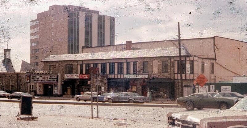
The trolley proved a boon to the village’s development, as did the covenants of neighboring Chevy Chase, which prohibited commercial establishments within the residential area. The new suburbanites needed a place to shop, and Bethesda would become that place. The first merchant to capitalize was Alfred Wilson, who, in 1890, built his new general store on the site of the old tollhouse, a few hundred feet south of the intersection of the pike and the old Georgetown road. It quickly became the center of community life, serving as the post office, the polling place and, in 1921, the village’s first library. The structure still stands, the oldest building in town and the only reminder of the community’s 19th-century crossroads beginning. (In 2017, to make way for a new office building above the Bethesda Metro stop, it was moved a few blocks to Middleton Lane, between the Bethesda Theatre and Pumphrey Funeral Home on the east side of Wisconsin Avenue).
In 1910, the Georgetown Branch of the B&O Railroad arrived, running through town on its way from Silver Spring into the District. The freight-only line brought new commercial growth along the tracks, with coal yards, lumber yards, a planing mill, an ice plant and more loading and off-loading at the Bethesda station, perched west of Wisconsin Avenue in an area called Miller’s Flats that ultimately became the site of Bethesda Row.
Despite the industrial growth, a rural quality prevailed in the village. Horses grazed in empty lots, and sheep and cattle roamed the fields on either side of Wisconsin Avenue. But soon a revolutionary presence arrived on the road—the automobile. Industrialist Henry Ford had introduced his affordably priced Model T in 1908, and in the first year of production more than 10,000 were sold. By 1926, nearly 15 million Fords were rolling down America’s streets and engendering the rise of the new automobile suburbs.
The trolley had jump-started growth, but the auto threw it into high gear. All around the village center suburban communities rose, vying with one another as they promised luxurious homes in beautifully landscaped surroundings just a short car trip to and from downtown D.C. offices. Early subdivisions such as Drummond, Bradley Hills, Battery Park, Kenwood and Leland competed for a rising upper-middle class of home seekers, noting in their advertisements that “adequate and proper restrictions will be placed in the deeds” to insure “a high character of development.”
In 1912, local real estate magnate Walter E. Tuckerman purchased 185 acres at the southwest corner of the pike and the old Georgetown road, carved it into 250 lots and created a community for “those of refined taste, demanding a better social atmosphere than surrounds the usual suburb, a more picturesque environment for an all-year-round home out of the city, without the expense and responsibility of a large estate.” His gated community, originally called Edgewood but renamed Edgemoor in 1916 to avoid confusion with another Maryland community and military installation of that name, provided all the modern amenities, including “pure artesian water, sanitary sewage, gas for cooking, heating and lighting, electric light and telephone service.”
Gracing the center of the community was a large green expanse reserved as a sports complex for residents. By 1920, two tennis courts had been built in the open field, with a small grandstand shaded by a broad awning. A clubhouse, swimming pool, bowling and putting greens soon followed. The Edgemoor Club, still operating on Exeter Road, would reach acclaim in the late 1950s when Pauline Betz Addie—ranked No. 1 in the world in 1946 and winner of six Grand Slam tennis titles, including Wimbledon, and Forest Hills four times—became the club pro.
Exclusive sports and social clubs soon became a trademark of Bethesda living. The older Chevy Chase Club, originally formed in 1892 as a hunt club, and the Columbia Country Club, which moved to its present location in 1910 and hosted golf’s U.S. Open in 1921, were soon joined by an array of others, forming a wide green ring around the village. The Montgomery Country Club was established in 1913 along the trolley line operated by the Washington and Great Falls Railway and Power Company, following a route that is now Bradley Boulevard. It was soon joined by the Town and Country Club, founded by members of Washington’s German-Jewish community. That club moved to the northern boundary of Bethesda in 1921 and became informally known as “Woodmont” for the subdivision immediately to its south, a name that became official in 1930. Out River Road, Congressional Country Club, catering to the political elite, opened in 1924, as did Burning Tree Country Club, an exclusively male bastion. Kenwood Golf and Country Club followed in 1928, and one year later the Montgomery Country Club would be converted into the National Women’s Country Club. “Men are experiencing the women’s revenge,” The Washington Post reported. “Women have a club of their own now—one of the finest nine-hole courses in the country.” In 1947, the property was renamed again and became Bethesda Country Club.
Bethesda’s commercial district responded to the suburban influx with equal gusto. In 1925, the Bank of Bethesda – also founded by Tuckerman, and originally housed in the gatehouse that marked the entrance to Edgemoor — tore down Lochte’s old blacksmith shop, which for half a century had stood on the northwest corner of the old Georgetown road and the pike (now rechristened Wisconsin Avenue). In its stead, the bank erected a handsome new stone headquarters, a building that, today dwarfed by its towering neighbors, served for many years as a branch of SunTrust Bank and still anchors the corner.
Farther down the avenue, residential developers and brothers Monroe and Robert Bates Warren would unveil an entirely new breed of commercial building: the shopping center. Completed in 1927, the picturesque, Tudor-style Leland Shopping Center offered an unbroken row of stores stretching south of the eastern corner of Leland and Wisconsin. Residents of adjacent communities could now enjoy a stroll along the avenue, eyeing wares neatly posed in the center’s display windows. Across the street, local developer George Sacks would open his own stone-fronted shopping center, with angled parking conveniently located out front and apartments on the second floor. The northern end featured Northwest Ford’s sparkling auto showroom. More than 80 years later, the two centers still cater to Bethesda shoppers.
Business was bustling in the 1920s, as was the traffic through the village center—so much so that, on July 8, 1930, the village’s first traffic signal appeared, installed at the intersection of Wisconsin, Old Georgetown and the newly completed East West Highway. A State Highway Administration 10-hour traffic count at the intersection in 1930 recorded 6,000 vehicles traveling along East West and Old Georgetown, and 8,000 vehicles on Wisconsin, making it the busiest intersection in the county. (By comparison, Wisconsin Avenue in 2010 had a daily average traffic count of more than 62,000 vehicles.)
The American economy rolled along with astonishing speed in the Roaring ’20s; fortunes were quickly made in stock and land speculation, and “a nice home in the suburbs” became de rigueur for the nouveau riche. Within a 10-year period, from 1920 to 1930, the population of Bethesda soared from 4,800 to 12,000, representing 30 percent of Montgomery County’s total population. Even the onset of the Great Depression in 1929 couldn’t dampen the explosive growth. The large number of government paychecks invested in home mortgages, filling the coffers of area banks and supporting local businesses, helped insulate Bethesda from the severe economic conditions ravaging the rest of the nation. County farmers banked on the village’s financial strength with the establishment of The Farm Women’s Cooperative Market in 1932, a self-help project selling locally grown produce out of a tent along Wisconsin Avenue. Later that year, the farm women would build a permanent market house on the east side of Wisconsin that has been in use ever since.
Stimulus money injected into the U.S. economy by President Franklin D. Roosevelt’s New Deal programs would bring new additions to the avenue’s streetscape. In 1938, under the auspices of the Works Progress Administration (WPA), a new, classically inspired post office was built on Wisconsin Avenue. The Colonial Revival building – like the Bank of Bethesda, the C&P Telephone Building, and several others — was constructed out of native stone trucked in from the Stoneyhurst Quarries out River Road. It served as a Post Office until 2012, and is now a yoga and fitness studio.
Then came two ambitious government projects that would have a monumental impact in shaping the community. In 1938, the National Institutes of Health (NIH) began development of its new research complex at the village’s northern end. Adjacent property owners, as well as the Bethesda Chamber of Commerce, were leery. The NIH campus would change the atmosphere of the neighborhood, they argued. It would be unhealthy for residents if the government were allowed to study infectious diseases so close to homes. But then Roosevelt visited the proposed campus and gave it his hearty approval.
While touring the property, FDR looked out over Rockville Pike, remarked on the bucolic Bethesda environs, and pointed out land he thought would be perfect for a proposed Naval Medical Hospital. The next year, builders broke ground on a soaring, 20-story steel-frame and reinforced concrete building designed by master French-American architect Paul Philippe Cret, who worked from a sketch by FDR himself that was inspired by the tower of the Nebraska State Capitol in Lincoln. At its completion in 1942, the Naval Medical Center, along with the NIH, would not only set a northern limit to the expansion of Bethesda’s commercial district, but would eventually bring thousands of new workers to the area’s busy streets—and thousands of new homeowners to the exploding suburban communities.
A few years earlier, entrepreneur Sidney Lust believed the growing prestige of Bethesda justified the building of a high-style, major modern theater, and he hired the noted architect John Eberson— designer of Silver Spring’s Silver Theatre, today home to the American Film Institute—to design a lively art deco facility. At its opening in 1938, local papers hailed the Lust theater — then called the Boro, soon renamed the Bethesda Theatre, and today known as the Bethesda Blues & Jazz Supper Club — as “a triumph in modern theatre construction,” and messages of congratulations poured in from such Hollywood personalities as Clark Gable, Gary Cooper, Spencer Tracy, Shirley Temple and W.C. Fields. The sumptuous interior included a “streamlined lobby painted in modern designs” with mirrors, display cases, an elaborate coved ceiling and indirect lighting. Off the domed foyer were “beautifully appointed” smoking rooms and lounges, and the stage was described by the Bethesda-Chevy Chase Tribune as “the largest in the suburban area and equipped to handle presentation acts.” The building further distinguished itself as one of the first in town to offer central air conditioning.
Moviegoers could grab a quick preshow meal at Bethesda’s new Little Tavern outlet, opened in 1939. Little Tavern was an early hamburger chain that promised “Cold Drinks, Good Coffee,” and urged patrons to “Buy ’em by the bag.” Founded in 1927 by Harry F. Duncan, the chain competed with other pioneering fast-food enterprises such as White Tower and White Castle, each of which had created a distinctive style of architecture to advertise their wares. The Little Tavern chain adopted the “Old English” style of a quaint, pitched-roof roadside eatery, yet constructed of such modern and reputedly more sanitary materials as Vitrolite, tile, Formica and aluminum alloys. (The building survives, and today is home to the Golden House Chinese restaurant at the intersection of Wisconsin and Cordell avenues.)
Between 1930 and 1940, Bethesda’s population more than doubled to 26,000. But all was not well in boomtown. Residents were becoming concerned about the haphazard appearance of their new commercial district. Fast-paced but fragmented development after World War I had left the village with a patchwork look, which some felt unbefitting its new status in the county. As one community leader noted in 1939, despite the fact that Bethesda was on its way to becoming the county’s major retail trade center, “in growing, it has developed a hodgepodge of conglomerated architecture in which brand new stores adjoin age-old frame houses, and the large and the small, the brick and the frame, the stone and the stucco are jumbled together.” Despite their plea for architectural quality, civic leaders had little control over what was built, and how the new shops and offices contributed to the expanding streetscape.
After World War II, as the nation headed into the halcyon days of the 1950s, the residential and commercial boom continued with vigor. But geographical restrictions—the circling of the business district by stable residential communities, country clubs and federal lands—worked to contain the downtown’s outward expansion. Development was forced upward, and by the 1960s, eight-, nine- and 10-story office buildings had begun to cast longer shadows on Wisconsin Avenue. The East Tower of the Air Rights Building on Wisconsin Avenue, completed in 1964, was one of the downtown’s first 10-story high-rises. Gradually, many older retail businesses were demolished in the face of ever-rising rents and land values. Local and national stores alike began to retreat to the new, sprawling outer-suburbia shopping centers that were starting to dominate the area’s retail scene. Wheaton Plaza, whose plans were laid in 1954, would offer consumers a wonderland experience, with covered walkways, major department stores and rows of specialty shops. It would become the first regional mall in the Washington area and, by 1963, the fourth largest in the United States. Then, in 1968, Montgomery Mall would take shopping to even greater heights as the area’s first totally enclosed, all-weather mall, further luring major retailers away from possible downtown Bethesda locations.
Meanwhile, the continuing patchwork nature of the downtown area continued to present a built environment with no distinguishable character of its own. John Westbrook, former head of the urban design division of the Maryland-National Capital Park and Planning Commission, recalled in the 1980s the Bethesda he first encountered in the early 1970s. “The central business area had no heart,” Westbrook said, “no sense of identity, exposed parking, concrete buildings mushrooming out of asphalt, no trees, no greenery. What was there was dying in the median strips.” Soon, however, the county would step in and attempt to control the architectural quality of any new construction—and bring a sense of place to the downtown area.
With the selection in 1972 of the Wisconsin Avenue and Old Georgetown Road intersection as the site of the Bethesda Metro subway station, a rush of new development in the downtown was inevitable. Again, the progress of transportation—from turnpike to trolley to automobile to subway—seemed destined to direct the town’s future. That sparked residents’ fears that Metro’s arrival would trigger even greater unregulated development, so the county government adopted a master plan in 1976. Citizens and planners agreed that the only options were spreading new construction throughout the district or concentrating it at one point. What the planning board eventually recommended was a pyramidal development scheme for downtown Bethesda, with the tallest buildings massed around a Metro station “core.” As buildings moved away from the town center, height limits would be reduced, stepping down to a scale more in keeping with that of the surrounding residential communities. Additional buffers between homes and offices were to be provided by interposed parks, playgrounds and public buildings.
In 1984, Bethesda’s Metro station opened—one year after the county had approved plans for 14 medium- to high-density buildings surrounding it in a package redevelopment plan unprecedented in the county’s history. When completed, the mélange of post-modernist architecture would add 3.1 million square feet of new commercial and residential space to Bethesda’s 9 million square feet of commercial space, with an estimated 13,000 to 15,000 new employees filling the office towers.
Though interrupted by the recession in 2008-10, the redevelopment of downtown Bethesda proceeds apace, with numerous office builds, apartments and condominiums completed over the past decade. Highlights of the past 25 years include the development of the Bethesda Row mixed use complex in the late 1990’s, and the transformation of the Woodmont Triangle. Once the “other side of the tracks” in Bethesda, today it is home to scores of restaurants and over a dozen high rise apartments/condos. For the past decade growth has accelerated in recognition of the fact that downtown Bethesda will be the western anchor of the Purple Line as well as the new headquarters of Marriott International, which is relocating from Democracy Blvd a few miles north.
We are a long way from the wide spot in the road.
Recent Stories
In December 2022, we let you know that Dunkin’ is continuing its massive expansion across the country and in MoCo, with an upcoming location coming to the Traville Village Center…
March Madness took on a new dimension this year as 16 middle schools engaged in their own version of the tournament: March MATHness, MCPS announced in its staff bulletin. The…
Montgomery County Public Schools (MCPS) released the following statement concerning the arrest of a student from Thomas S. Wootton High School in Rockville:

Five MCPS graduating seniors have received 2024 Amazon Future Engineer Scholarships worth up to $40,000 over four years to pursue a degree in computer science or engineering, according to MCPS….
17th Annual Kensington Day of the Book Festival
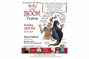
Now in its 17th year, the Kensington Day of the Book Festival is a family-friendly street festival featuring 150+ renowned authors, poets, and literary organizations. Enjoy live music on five stages, special guest speakers, military veteran writers and comedians, poetry readings, cookbook demos, children's program, and much more.
Admission is free, and attendees will also be able to explore a marketplace of books and food offerings from local vendors.
Not your average book festival! This festival offers something for everyone!
17th Annual Kensington Day of the Book Festival
Sunday, April 21, 2024, 11am-4pm (held rain or shine!)
Howard Avenue, Kensington, MD 20895
www.dayofthebook.com
Instagram: @kensingtonbookfestival
Contact: Elisenda Sola-Sole, Festival Director
301-949-9416 (text preferred)
FEST OF SPRING Caribbean Wine Food & Music Festival

Get ready to experience the vibrant colors, tantalizing flavors, and infectious rhythms of the Caribbean at the FEST OF SPRING Caribbean Wine Food & Music Festival! Hosted by RHU LLC, this exciting festival is set to take place on May 18, 2024, at the picturesque 16700 Barnesville Rd in Boyds, MD.
Step into a world where the Caribbean spirit comes alive! From 12:00 PM onwards, immerse yourself in a sensory journey that celebrates the unique culture, cuisine, and music of the Caribbean. Whether you're an African American, a Reggae or Soca music enthusiast, a wine lover, or part of the vibrant Caribbean diaspora, this festival promises to delight and captivate you in every way.
Let the enticing aromas of mouthwatering Caribbean dishes tantalize your taste buds. Feast on traditional delicacies prepared by expert chefs, showcasing the rich and diverse culinary heritage of the Caribbean. Indulge in flavorful jerk chicken, succulent seafood, and delectable plantain dishes that will transport you straight to the islands.
Accompanying the culinary extravaganza is a carefully curated selection of premium wines, ensuring the perfect pairing for your palate. Sip on fine wines from renowned vineyards, each sip a reflection of the Caribbean's vibrant spirit. Discover new flavors, expand your wine knowledge, and savor unforgettable moments with every glass.
As the sun sets, get ready to groove to the infectious rhythms of Caribbean music. Feel the pulsating beats of reggae, soca, dancehall, and calypso, moving your body to the lively melodies. Live performances by talented musicians and performers will keep the energy high, ensuring a night of unforgettable entertainment.
Don't miss this opportunity to embrace the Caribbean spirit and celebrate the arrival of spring in style! Tickets are available on AllEvents, so secure your spot today. Join us at the FEST OF SPRING Caribbean Wine Food & Music Festival, where cultures collide and unforgettable memories are made.
LIVE PERFORMANCES By: CULTURE Feat. Kenyatta Hill, EXCO LEVI, IMAGE BAND, RAS LIDJ REGG'GO with Special Guest SUGAR BEAR FROM E.U. & MORE! & MORE!
MUSIC By: DJ ABLAZE, DJ SMALLY & NAJ SUPREME
2 NIGHT Camping packages available: RV/CAMPER $200 | TENTS $150 Starting on Friday May 17 @ 5pm | 30 RV SPACES | 30+ TENT SPACES
KIDS 12 & UNDER FREE!!!