
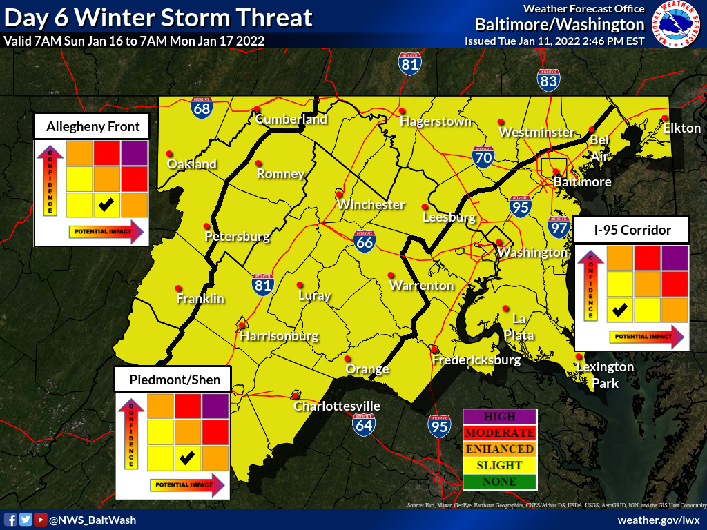
The National Weather Service has a slight winter storm threat for our areas on days 6 and 7, for potential winter weather this upcoming Sunday and Monday.
As it looks now the threat seems to be between Saturday night and Sunday night (and potentially Monday night), but anyone who has experienced winter in the area knows how quickly things can change when it comes to potential winter weather.
The GFS (American model) has fared well this winter, sniffing out our last two previous winter storms before the Euro (European model), which tends to be a little more accurate with long range winter forecasts.
Both models are currently showing potential for this weekend, but there are a lot of moving parts.
Fox 5’s Mike Thomas tweeted some raw data earlier this afternoon that shows potential outputs from both the GFS and Euro. The GFS shows a significant storm that could potentially bring 6 inches or more to MoCo, while the Euro has the edge of the storm running through the county with 6 inches upcounty and an inch or so closer to DC.
As Mike Thomas notes below, this is very likely to change.
Already have an inbox full of questions…so here is what forecasters are watching for SUN/MON period.
PLEASE NOTE – This is raw data. These numbers are VERY likely to change & there is still a path to absolutely nothing. So I encourage caution & stay tuned. American/Euro shown pic.twitter.com/L1cHLUwR6G
— Mike Thomas (@MikeTFox5) January 11, 2022
Below you’ll see the “forecaster’s discussion” from the NWS.
An upper low feature currently situated just off the NW coast will begin to shoot down across the CONUS. Following its initial path across the western third of the CONUS will allow for ridging in its wake. A cutoff low will subsequently shoot down near the Tennessee Valley by Saturday night with a coastal low poised to form off the Carolina coastline.
This, along with subtropical ridging across the western Atlantic will keep the low tracked most likely closer to the coastline than further south. Main uncertainty now is the exact track of the low.
This will greatly influence the potential for a widespread snowfall for the Mid- Atlantic or even the potential for snow in the mountains and maybe a slight severe threat further east. GEFS 12z guidance has come a little bit more in agreement to EPS (a bit further south) but overall trends are still favoring a significant snowfall event somewhere between central NC and closer to the Mason-Dixon line and points further NE.
Recent Stories

The Maryland State Police have released information regarding its participation in this Saturday’s National Drug Take Back Day.

Transportation Security Administration (TSA) officers have announced that it had intercepted its sixth gun at a security checkpoint so far this month.
Mayor Jud Ashman and members of the City Council hosted the 2024 State of the City address on Thursday, April 18, at Asbury Methodist Village.
Below is a list of businesses that have recently opened, closed, or are coming soon to Wheaton Mall at 11160 Veirs Mill Rd.
FEST OF SPRING Caribbean Wine Food & Music Festival

Get ready to experience the vibrant colors, tantalizing flavors, and infectious rhythms of the Caribbean at the FEST OF SPRING Caribbean Wine Food & Music Festival! Hosted by RHU LLC, this exciting festival is set to take place on May 18, 2024, at the picturesque 16700 Barnesville Rd in Boyds, MD.
Step into a world where the Caribbean spirit comes alive! From 12:00 PM onwards, immerse yourself in a sensory journey that celebrates the unique culture, cuisine, and music of the Caribbean. Whether you're an African American, a Reggae or Soca music enthusiast, a wine lover, or part of the vibrant Caribbean diaspora, this festival promises to delight and captivate you in every way.
Let the enticing aromas of mouthwatering Caribbean dishes tantalize your taste buds. Feast on traditional delicacies prepared by expert chefs, showcasing the rich and diverse culinary heritage of the Caribbean. Indulge in flavorful jerk chicken, succulent seafood, and delectable plantain dishes that will transport you straight to the islands.
Accompanying the culinary extravaganza is a carefully curated selection of premium wines, ensuring the perfect pairing for your palate. Sip on fine wines from renowned vineyards, each sip a reflection of the Caribbean's vibrant spirit. Discover new flavors, expand your wine knowledge, and savor unforgettable moments with every glass.
As the sun sets, get ready to groove to the infectious rhythms of Caribbean music. Feel the pulsating beats of reggae, soca, dancehall, and calypso, moving your body to the lively melodies. Live performances by talented musicians and performers will keep the energy high, ensuring a night of unforgettable entertainment.
Don't miss this opportunity to embrace the Caribbean spirit and celebrate the arrival of spring in style! Tickets are available on AllEvents, so secure your spot today. Join us at the FEST OF SPRING Caribbean Wine Food & Music Festival, where cultures collide and unforgettable memories are made.
LIVE PERFORMANCES By: CULTURE Feat. Kenyatta Hill, EXCO LEVI, IMAGE BAND, RAS LIDJ REGG'GO with Special Guest SUGAR BEAR FROM E.U. & MORE! & MORE!
MUSIC By: DJ ABLAZE, DJ SMALLY & NAJ SUPREME
2 NIGHT Camping packages available: RV/CAMPER $200 | TENTS $150 Starting on Friday May 17 @ 5pm | 30 RV SPACES | 30+ TENT SPACES
KIDS 12 & UNDER FREE!!!