
Maryland could see multiple chances for wintry weather over the coming days, with several light systems on track to move through the region. While no major storm is guaranteed at this point, the probability of seeing at least an inch of snow is climbing for much of the state.
According to the latest data from the European model, much of Maryland sits at around a 50% chance of receiving one inch or more of snow between now and Sunday. Western Maryland’s probabilities are noticeably higher thanks to colder air and more favorable terrain, while southern Maryland is closer to 30%.
The midweek system arriving tomorrow (Wednesday) is expected to fall as all rain across central Maryland, with temperatures too warm to support snow outside the mountains. A weak disturbance arriving Friday could deliver a light, powdery snowfall, especially during the afternoon and evening.
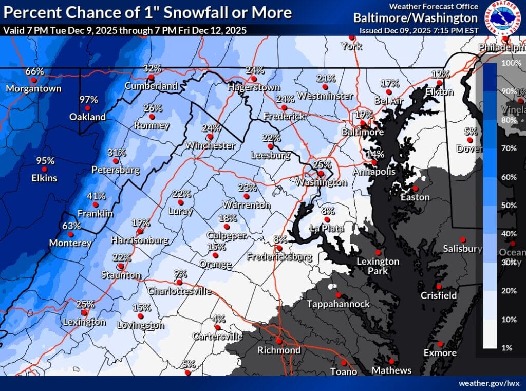
- National Weather Service (NWS) currently places the chance of at least one inch at about 25%.
- Most model solutions point to anywhere from a coating to an inch, though some areas may see nothing if the track shifts.
The NWS notes that cold air will be firmly in place, and any precipitation should fall as snow. Because the strongest lift intersects the dendritic growth zone (prime snow-flake-making territory), the system is expected to produce dry, fluffy snow with high snow ratios. Snow could begin west of the Blue Ridge during the morning and spread east through the afternoon.
Another system late Saturday night into Sunday remains the most intriguing, but also the most uncertain, chance for snow. If everything lines up, it could produce the highest snowfall totals of the season so far, which isn’t saying much given that most of the region has only seen 0.5–1.5 inches this winter. Still, it’s notable that the setup even allows for a more significant event this early, with winter not officially beginning until later this month.
Here is an excerpt from the National Weather Service’s latest forecast discussion addressing the Friday event:
“A weak disturbance embedded within west-northwesterly flow aloft will approach from the Ohio Valley on Friday. Precipitation associated with this system will be light, but 12z guidance has trended slightly upward… Temperatures may briefly climb into the mid to upper 30s, but would quickly wet-bulb back below freezing with onset of precipitation… Precipitation type is expected to be all snow… Snow totals will likely be on the lighter side, with most model solutions showing between a coating and two inches… Given potential impacts to the Friday evening commute, this system will bear watching over the coming days.”
The upcoming week is shaping up to be one of the more active stretches of the early season. With three systems between now and Sunda, each capable of producing at least some snow, forecast updates will be important as the details come into focus. We will continue to monitor trends and provide updates as each potential event gets closer.
