
Snow is expected to blanket the region (DC, Maryland, and Virginia) on Sunday, with impacts likely to stretch into the start of next week, according to the latest thinking shared by NBC4 meteorologist Amelia Draper.
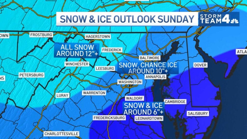
In a social media update, Draper described Sunday as a “Snowy Sunday” and outlined expected snowfall amounts, noting that the plus signs on the forecast indicate the potential for even higher totals in some areas.
The biggest remaining question is whether sleet mixes in at any point during the storm. While that could influence exact snowfall totals, Draper stressed that it will not change the overall impact. Whether the precipitation falls as all snow or a mix of snow and sleet, travel conditions are expected to deteriorate.
Main roads are expected to be a mess from Sunday through at least midday Monday, with snow-covered and icy conditions making travel difficult even after the heaviest precipitation ends.
School disruptions are also expected to last beyond the storm itself. Draper said closures and delays are likely to extend into Tuesday and possibly Wednesday as crews work through cleanup and lingering hazardous conditions.
View this post on Instagram
Snowy Sunday!
Here is what I am thinking now for snowfall amounts (the “+” means or more)
The biggest question; does sleet mix?
Regardless impacts are the same … main roads are a mess Sunday into midday Monday
Schools are closed and/or delayed into Tuesday/Wednesday pic.twitter.com/2wE1HRIn76
— Amelia Draper (@amelia_draper) January 21, 2026
