
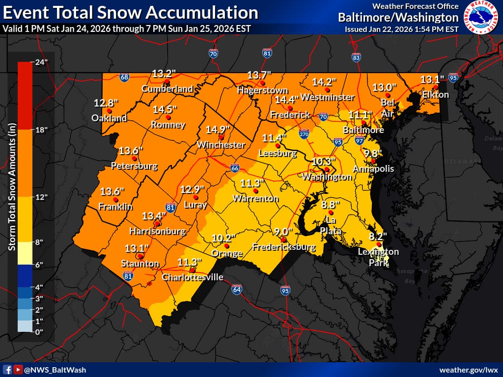
The National Weather Service has released its first call map for total snowfall from a potentially major winter storm expected to impact the region this weekend, showing widespread totals in the 10 to 14 inch range across much of the area.
The early forecast highlights a broad swath of significant snow from Saturday afternoon through Sunday evening, with much of central Maryland, the District of Columbia, and northern Virginia falling squarely within double digit snowfall projections. Higher totals are indicated north and west of the metro area, while slightly lower amounts appear closer to the immediate Chesapeake Bay and southern zones where mixing may occur.
The first call map aligns with a Winter Storm Watch that remains in effect from Saturday evening through Monday morning. Forecasters say a large area of precipitation will overrun Arctic air already in place across the Mid Atlantic, a classic setup for a high impact winter storm.
Per the Winter Storm Watch, snow is expected to overspread the region late Saturday and become heavy at times Saturday night. Snowfall rates could reach one to two inches per hour during the most intense periods. On Sunday, sleet and freezing rain may mix in, especially south of Highway 50 and near and east of Interstate 95. Significant icing is possible in those areas, which could reduce snow totals but increase overall impacts.
There is a high likelihood of at least five inches of snow across the region, with totals over ten inches possible in many locations. Ice accumulation adds another layer of concern, particularly for travel and potential power disruptions.
Beyond the snow and ice, dangerously cold conditions are expected to follow the storm. Very cold temperatures are forecast from Friday night through the middle of next week, with wind chills falling into the teens and single digits for extended periods. Sub zero wind chills are possible at times, making conditions hazardous even after the snow ends.
Travel could become very difficult, especially late Saturday night through Sunday, and impacts may extend into the Monday morning commute due to lingering snow, ice, and frigid temperatures. Residents are encouraged to continue monitoring forecast updates as details on snowfall totals and ice potential are refined.
View this post on Instagram
