
Severe thunderstorms capable of producing damaging winds and possible tornadoes are expected across the Washington, D.C. region this afternoon and evening, according to the National Weather Service (NWS).
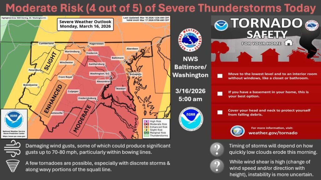
NWS forecasters have shared a “Hazardous Weather Outlook” and has placed much of central Maryland, northern Virginia, and Washington, D.C. under a Moderate Risk (level 4 of 5) for severe weather on Monday, March 16. The outlook includes the Maryland portion of the Chesapeake Bay, the Tidal Potomac River, and the I-95 corridor through the region.
The National Weather Service says severe thunderstorms are likely later today, with the primary threat being damaging wind gusts that could reach 70 to 80 mph. “A few tornadoes are possible, especially with discrete storms and along wavy portions of the squall line,” forecasters said in the Hazardous Weather Outlook.
Outside of thunderstorms, strong winds may also create issues. Wind Advisories have been issued across northeastern Maryland from 2pm to 10pm, and officials warn that strong non-thunderstorm wind gusts could still lead to isolated instances of wind damage elsewhere during the afternoon.
The NWS says the exact timing of storms will depend on how quickly low clouds clear out during the morning hours. However, the strongest storms are expected to move through the region during the late afternoon and evening.
Residents are urged to stay weather aware throughout the day and be prepared to take shelter quickly if warnings are issued. The National Weather Service advises people to move to the lowest level of their home and into an interior room without windows, such as a closet or bathroom, if a tornado warning is issued.
