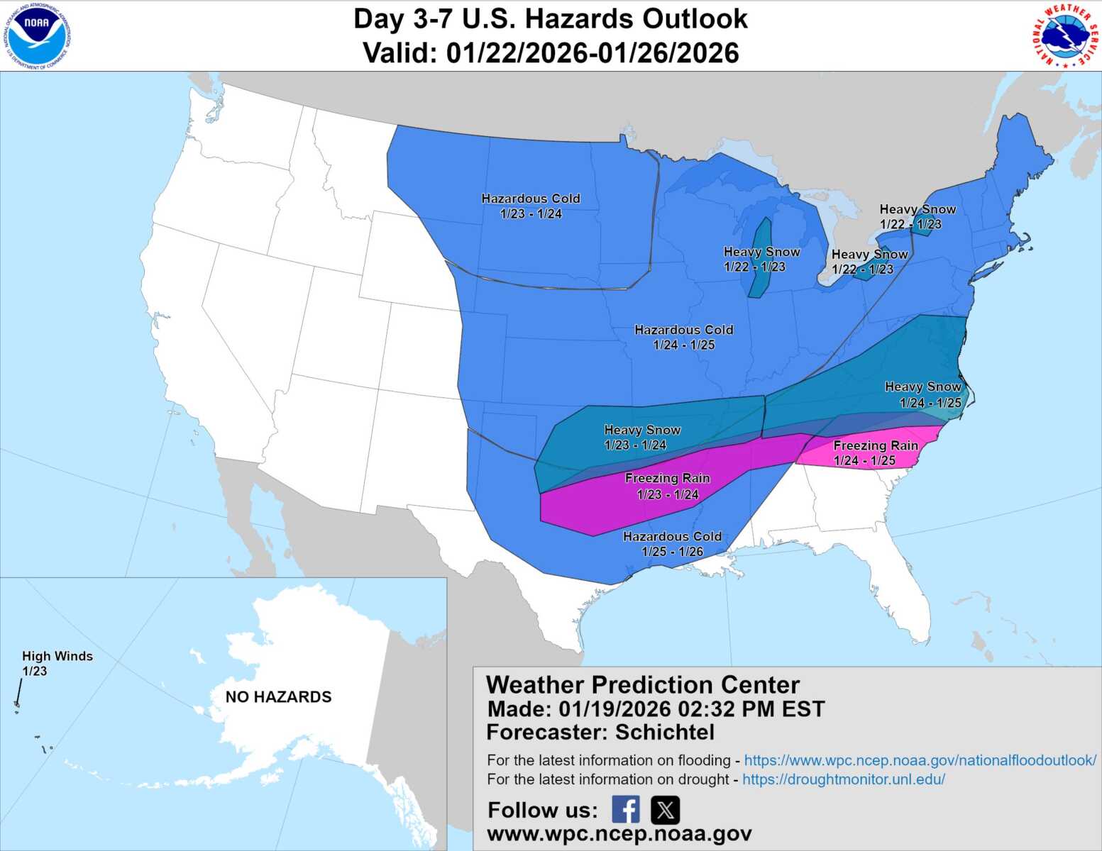
The National Weather Service is showing increasing confidence in the potential for a significant winter storm to impact the region this weekend, followed by a stretch of dangerously cold temperatures heading into next week.
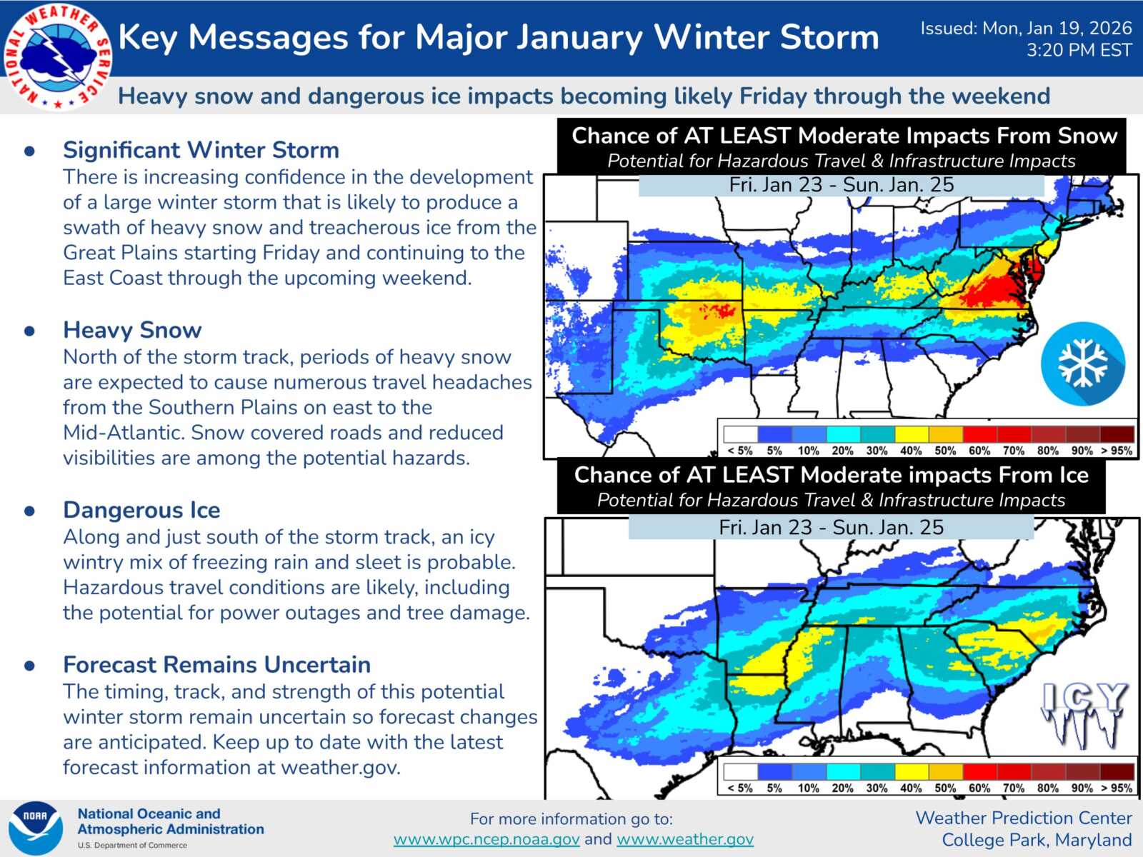
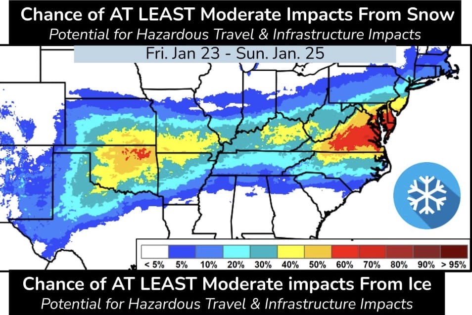
According to National Weather Service outlook graphics and forecaster discussions issued Monday, a large winter system is expected to develop from Friday through Sunday (starting Saturday night for our area, as of Monday afternoon), bringing the potential for heavy snow and hazardous travel conditions across much of the Mid-Atlantic. The Weather Prediction Center highlights a growing chance of at least moderate winter storm impacts, with infrastructure and travel concerns becoming more likely as the system evolves.
The pattern begins late Thursday into Friday as a potent cold front moves through the region. That front will be quickly followed by a reinforcing Arctic front late Friday into Saturday, allowing progressively colder air to spill southward. Temperatures are expected to fall each day from Thursday through the weekend, with sharply colder conditions settling in by Sunday.
The National Weather Service notes that well below average temperatures are expected, especially by Sunday. Extremely cold conditions are becoming likely Sunday night into early next week, with overnight lows forecast to drop into the single digits. Wind chills may fall to zero or below, and near-record low temperatures are possible, raising concerns for prolonged cold exposure and ongoing travel issues even after snowfall ends.
The latest 12Z forecast guidance continues to support the possibility of a significant snow event this weekend. One key trend noted by forecasters is a slightly later onset of precipitation, with the heaviest snow now most likely to occur from Saturday night through sometime Sunday afternoon.
One encouraging change in the forecast is a decreasing ice threat. Probabilities for freezing rain have dropped to nearly zero, largely due to a strong Arctic high pressure system to the north that is expected to keep temperatures cold enough at the surface and aloft for precipitation to fall mainly as snow.
At this time, National Blend of Models probabilities show a 40 to 60 percent chance of at least 6 inches of snow across the area, with a 20 to 30 percent chance of totals reaching 1 foot. While those numbers do not guarantee those outcomes, they reflect a strengthening signal that forecasters are watching closely.
Some weather apps are already highlighting individual model runs that depict feet of snow for the region. We caution that these extreme scenarios should not be taken literally at this point. High-end snowfall totals frequently appear in long-range guidance and can change dramatically from run to run. Until those outcomes begin showing up consistently across multiple models and within a shorter window closer to the storm, they remain low-confidence and speculative rather than a reliable forecast.
While details such as exact snowfall totals and timing will continue to shift, the overall message from the National Weather Service is becoming clearer… the potential for a high-impact winter storm this weekend is increasing.