
A powerful winter storm is shaping up to impact a large portion of the eastern United States late next week, with forecasters increasingly confident that the event could bring widespread disruptions lasting several days. As it stands on Tuesday morning, the National Weather Service (NWS), shows a good chance for moderate impacts in much of Maryland and Virginia.
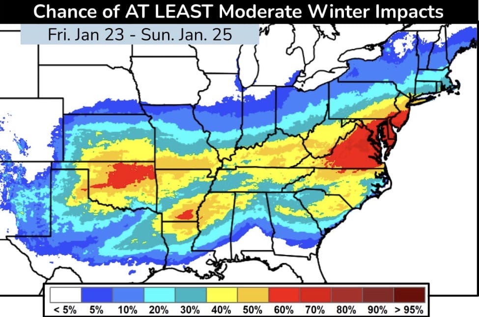
The image shows the probability of at least moderate winter impacts from Friday, January 23 through Sunday, January 25. Much of the central and eastern U.S. is highlighted, with the highest probabilities focused across the Mid-Atlantic, including Maryland, Virginia, and surrounding states. Areas shaded in red indicate a 60 to 70 percent chance of moderate or greater winter impacts, which typically include significant snow or ice, hazardous travel, and potential power issues.
Meteorologist Jim Cantore emphasized the seriousness of the setup, stating, “VERY HIGH IMPACT event that will last well beyond the falling precipitation into next week. Expect major disruptions to daily routines.” That warning underscores that this system is not just about snowfall totals, but also about lingering effects such as extreme cold, refreezing, difficult road conditions, and prolonged recovery time.
Unlike quick-hitting winter storms, this pattern appears to involve a sustained feed of cold air, meaning impacts could extend well after the main precipitation ends. That increases the likelihood of school closures, delayed reopenings, flight cancellations, and challenges for emergency services and utility crews.
While exact snowfall and ice amounts will become clearer closer to the event, the broad area of elevated probabilities suggests this is not a narrowly focused storm. Residents across the Mid-Atlantic and much of the eastern U.S. should begin monitoring forecasts closely, reviewing winter preparedness plans, and planning for potential disruptions to travel, work schedules, and daily activities.
As always with winter weather at this range, details will evolve, but confidence is growing that late next week could bring one of the more impactful winter events of the season.

