

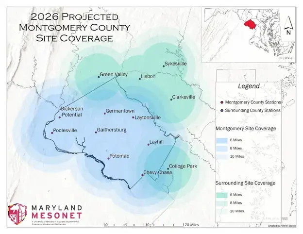
Montgomery County has activated a new weather station in Laytonsville as part of an expansion intended to improve local weather monitoring and help emergency officials respond to severe storms, flooding, and other hazards.
The station, installed at the Oaks Landfill, went live on September 2 and marks the first locally funded extension of the Maryland Mesonet, a network of automated weather stations operated by the University of Maryland. Additional stations are planned for Gaithersburg, Germantown, and Chevy Chase/Silver Spring, with all three expected to come online by the end of the year.
An additional flood sensor will also be placed in Laytonsville to help first responders detect rising water at low-water crossings. According to the County, 40 flood sensors have already been installed across Montgomery County.
“Climate change has made it critical that we focus on resiliency,” said County Executive Marc Elrich. “The Mesonet stations are an important network of automated weather stations that seek to fill gaps and help us prepare for storms that may affect targeted areas of the community.”
The solar-powered stations measure air and soil temperature, humidity, soil moisture, wind speed, atmospheric pressure, precipitation, and other environmental conditions. County officials say the observations help fill gaps in existing weather monitoring and can give emergency managers additional time to prepare for dangerous conditions. Soil temperature readings can also help anticipate snow and ice accumulation.
Once the expansion is complete, 95% of Montgomery County residents and businesses will be within seven miles of a station, according to OEMHS Emergency Management Specialist Matt Mizorko.
“We will have continuous, community-level weather data in the County to help with proactive decision making,” Mizorko said.
The expansion is supported by the County’s Climate Change Officer, Sarah Kogel-Smucker, with funding from the Climate Change Planning Non-Departmental Account. The stations will also support weather and climate-tracking goals outlined in the County’s Climate Action Plan.
University of Maryland officials say the network will provide both immediate information for emergency response and a growing record of local climate conditions. Data from the stations will be available to the public, first responders, and the National Weather Service through the Maryland Mesonet website.
