The National Weather Service has issued a Flood Warning for all of Montgomery County from now until 4pm this afternoon. Per the NWS:
* WHAT…Flooding caused by excessive rainfall continues.

The National Weather Service has issued a Flood Warning for all of Montgomery County from now until 4pm this afternoon. Per the NWS:
* WHAT…Flooding caused by excessive rainfall continues.

Tomorrow we’ll be a week into May, but it may not feel that way as temperatures aren’t expected to go higher than the low 50s at any point this weekend. Rain has moved into the area and is likely to fall off and on throughout the day today with temperatures getting to about 60°.
This weekend will bring more rain and temperatures are likely to remain between 40° and 54° on both Saturday and Sunday. We’ll see a slight warm up on Monday after the rain clears out and highs reach the upper 50s and then a slow climb throughout the week before highs are once again in the 70s by the end of the week.

There is a Freeze Warning in effect from 1am until 9am Thursday morning for northwest Montgomery County, which includes Germantown, Clarksburg, Poolesville, Damascus and some surrounding areas. A Freeze Watch is also in effect for late Thursday through Friday morning. Additional information below, courtesy of the National Weather Service:
* WHAT…For the Freeze Warning, sub-freezing temperatures as low as 31 expected. For the Freeze Watch, sub-freezing temperatures as low as 31 possible.

We’ve had a small streak of cooler days, but things should get a little more comfortable today as highs are expected to hover around 60° with plenty of sunshine.
Each day this week should get warmer with Thursday expected to get to the low/mid 60s with a mix of clouds and sun and a small chance of rain.
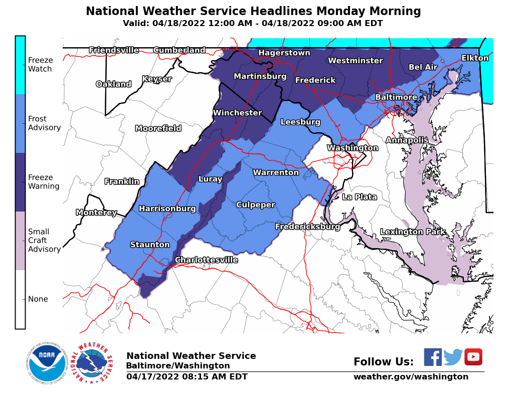
Per the National Weather Service:
There will be a frost advisory in effect from midnight tonight until 9am Monday morning.

Coming off of a warm day where temperatures hovered around 80°, today is expected to be the warmest day of the year so far with temperatures reaching the low to mid 80s for many of us.
Temperatures are expected to be in the 60s by 8am, 70s by 11am and into the 80s this afternoon with the “real feel” a few degrees warmer. Skies are expected to be sunny with a few clouds mixing in.

A Dense Fog Advisory is in effect this morning until 10am for most the of the DC Metro area, including all of Montgomery County.
Clouds will stick around after the fog this morning , but the sun should start peek through and temperatures will likely reach the mid 70s in the afternoon.

Snow totals are in from across the county after today’s snow storm that made things messy from the morning until the early afternoon across the area.
The forecast for this storm was fairly accurate, as expected snowfall for the area were between 2-5” depending on your location in the county
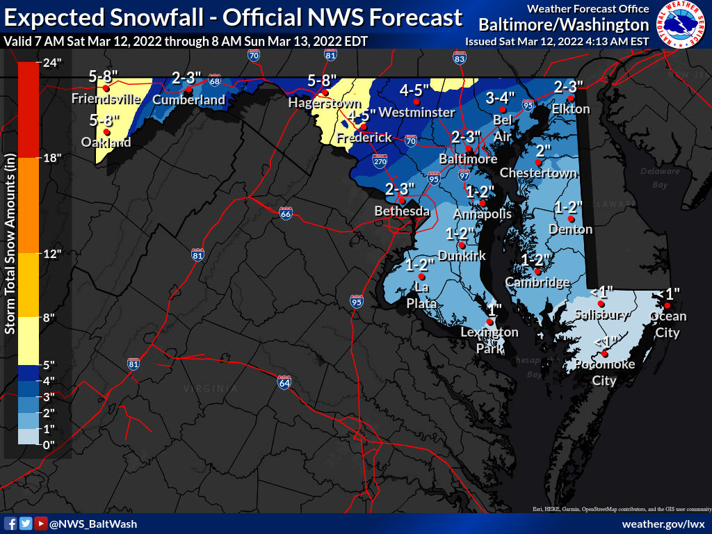
Per the National Weather Service, “rapidly deteriorating conditions expected across the Washington and Baltimore metropolitan areas as well as northeastern Maryland by 9 AM this morning as rain changes to heavy snow. Rates of 1-2″ per hour are possible at times with gusty winds.”
Winter Storm Warning for NW MoCo, Winter Weather Advisory for C/SE MoCo.

The National Weather Service has upgraded NW MoCo to a Winter Storm Warning from 6am until 3pm. C/SE MoCo remains under an advisory from 7am until 3pm.
Winter Storm Warning (NW MoCo)
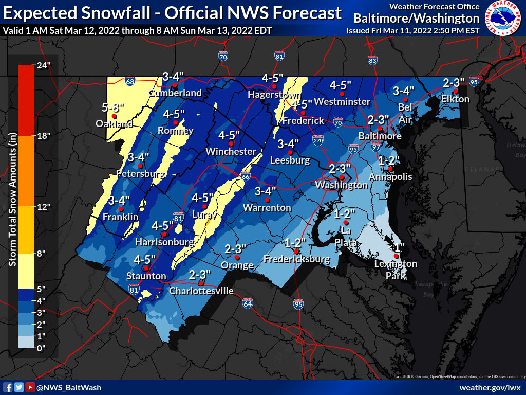
A Winter Weather Advisory is now in effect for all of MoCo from 7am until 3pm on Saturday.
Per the National Weather Service: