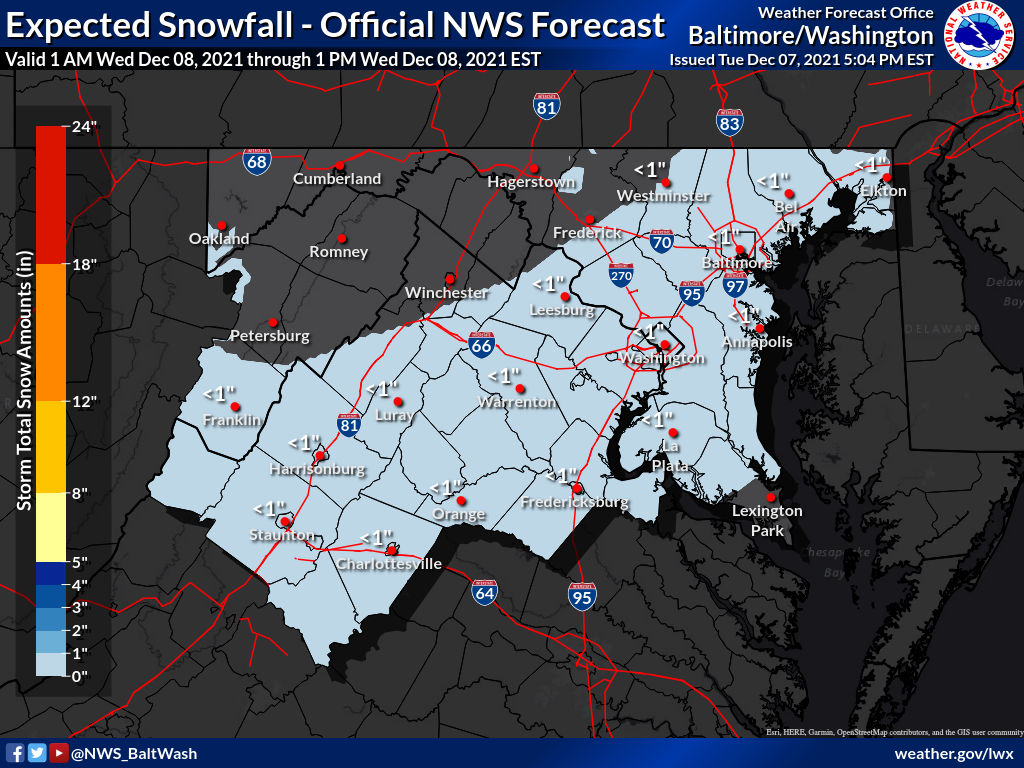
Not much has changed since our previous update letting you know not to expect much out of potential winter weather tomorrow morning.

Flurries or light snow may fall between 7am and 1pm tomorrow. If anything falls, there will more than likely be no disruption to travel as roads will just be wet.

The National Weather Service is referring to this system as a “minor disturbance” that may produce a period of light snow or flurries between 7am and 10am.

Per the NWS:

Temperatures will be near freezing for most areas early Wednesday before rising above freezing by mid-morning. If light snow occurs, it could coat untreated surfaces.

The tweet below shows how the storm looked over the last 16 runs of the GFS model (it runs four times a day, so you’ll see how it looked for the last four days). It goes from a storm that could have brought a couple inches to our area, to flurries and maybe a dusting.

Pencil Prediction for Wednesday, December 8: 1 Pencil

3 Comments

At 7:35pm, the National Weather Service provided its latest thinking on the potential winter storm set to arrive late Tuesday (December 7th) into Wednesday (December 8th).

“Here’s our latest thinking on the system set to arrive late Tue into Wed. Check out forecast amounts and the higher end potential. Keep in mind, Mon will be warm but it will be short lived as a strong cold front moves through bringing 30-40 mph wind gusts.”

As you can see in the image above, the thinking right now is that any wintry precipitation will be very light of any at all, but the “high end amount” (which has a 10% chance of occurring) is at approximately 2 inches for almost all of MoCo.

We’ll continue to monitor this storm to see if anything changes as we get within 48 hours.


2 Comment

The week will start off with its coldest day, as highs today will likely reach the mid 40s with light winds making it feel a bit cooler. Partly sunny skies are expected.

Temperatures will slowly climb as the week continues, as Tuesday is expected to hit the upper 40s with very little wind. Mostly sunny.

Wednesday, the first day of December, should hit 50° with mostly cloudy skies, but not much wind.

Thursday looks to be the warmest day of the week with temperatures reaching the low 60s . Plenty of clouds, but the milder weather will make up for it.

Friday should see increased sunshine with temperatures in the upper 50s.

Temperatures are likely to drop over the weekend with highs on Saturday in the low 50s and Sunday in the mid 40s.

0 Comments

Thanksgiving Week Weather

We’re about a month away from winter and the colder weather is starting to catch up. This week will start off with below average temperatures with today coming in close to average as highs will be near 50°. Rain is possible early on, but things will clear up in the afternoon.

Tuesday and Wednesday will be colder with temps in the mid 40s, but Thanksgiving day will bring above average temperatures with highs in the upper 50s.

Colder weather will return in time for the weekend with Friday highs in the low/mid 40s and and Saturday/Sunday in the mid 40s.

Monday, 11/22: 50° Rain possible early

Tuesday, 11/23: 44° Colder with a breeze

Wednesday, 11/24: 47° Sunny

Thursday, 11/25 🦃: 57° Mostly Sunny

Friday, 11/26: 43° with a breeze

Saturday, 11/27: 46° Mix of clouds and sun

Sunday, 11/27: 46° Mostly Cloudy


Sunday, 11/28:

0 Comments

A Wind Advisory will be in effect from noon today until midnight in Montgomery County

Per the National Weather Service:

“A strong low pressure system offshore will bring strong winds across much of the area today. A Wind Advisory has been issued along/west of the Blue Ridge and along/north of the I-66 corridor from noon today until midnight Wednesday.”

Montgomery County Fire and Rescue warns that we should expect NW winds or 25-35mph and gusts up to ~50mph.

IMPACTS: Gusty winds could blow around unsecured objects. Tree limbs could be blown down and a few power outages may result.

0 Comments

Summer is coming to an end tomorrow (Tuesday, 9/21) and though it may feel warmer a few days, it currently looks like highs will remain below 80° for the foreseeable future.

Tems will be in the upper 70s for the last two days of summer (Monday and Tuesday), with an increasing chance of rain as we get into the middle part of the week.

As of now here’s what to expect:

Monday, 9/20: 77°, partly sunny 🌤
Tuesday, 9/21: 78°, partly sunny 🌤

🍂 Fall Begins 🍂

Wednesday, 9/22: 77°, mix of sun/clouds, rain 🌦
Thursday, 9/23: 74°, rain likely 🌧
Friday, 9/24: 69°, cooler, mix of clouds/rain ⛅️

Weekend: Low 70s, partly sunny 🌤⛅️

Extended: Highs in the low to mid 70s all the way into the first week of October.

Many don’t realize that these forecasts change just as often as winter weather forecasts, so everything is subject to change, but this is how things are looking as of early this morning.

Will we hit 80° again this year? Probably, but it’s currently not in the forecast.

2 Comment

The Farmers’ Almanac has released its 2021-2022 extended winter outlook.

MoCo and almost all of Maryland seem to fall under the “Typical winter chill, Stormy January, Tranquil February” category. Just to our south is the “Quite chilly, mixed bag of precipitation” category that we may be a little more used to in recent years.

“According to the Farmers’ Almanac’s time-tested weather formula, there will be snow, but probably not as much as a snow-sport enthusiasts might dream of. On average, we’ll see near-normal amounts of the white stuff from coast to coast. However, there will be notable month-to-month variations.”

We asked our resident show forecaster, MoCoSnow, what this means. “I think they’re playing it safe. Saying we’ll see near-normal amounts of snow kind of covers you if you’re a little below or a little above average.”

All in all, it’s a forecast that allows you to have a little fun as summer winds down and we prepare for chillier temperatures. Only time will tell if the farmers’ 2021-2022 Winter Outlook will hold true.

0 Comments

Weather Cooperates this Weekend for Pool Lovers

Last week we discussed the disappointing weather for pool lovers and those who generally enjoy being outside for Memorial Day weekend, as the area was dealing with chilly temperatures and rain for most of the weekend.

Though things got better on Monday in regards to the rain, the low 70s were still not warm enough for most to make it out to the pool. This weekend will do its best to make up for it as both today and tomorrow will see temperatures in the 90s with plenty of sun.

Temps are expected to reach the low 90s today with virtually no chance at any rain. It’ll feel like the upper 90s with humidity. Tomorrow will feel even warmer as we reach the mid 90s with humidity making it feel like it’s about 100°.

If you didn’t get a chance to make it to the pool yet, this may be your opportunity. Temperatures are also expected to hover around 90° for the better part of next week until things cool down a bit for the weekend.

Featured photo courtesy of the National Weather Service.

0 Comments

Humidity Could Make it Feel Like 100° Today, Disappointing Weather Memorial Day Weekend

Temperatures are likely going to reach the low to mid 90s today and it’s going to feel like it’s almost 100° for a few hours in the early afternoon.

We have higher chances of rain in the morning and late afternoon/evening, but the threat lingers throughout the day. The thunderstorms later in the day could come with hail and damaging winds.

Memorial Day Weekend is a different story. Temperatures on Saturday aren’t expected to go much higher than 60° with a high chance of rain throughout the day. Sunday isn’t looking much better, with highs in the mid 60s and more clouds than sun. Monday will be pleasant with temperatures in the 70s, but it doesn’t look like this weekend is coming with “pool weather.”

The weekend is still a few days out, so keep those fingers crossed and stay cool today.

0 Comments
×

Subscribe to our mailing list