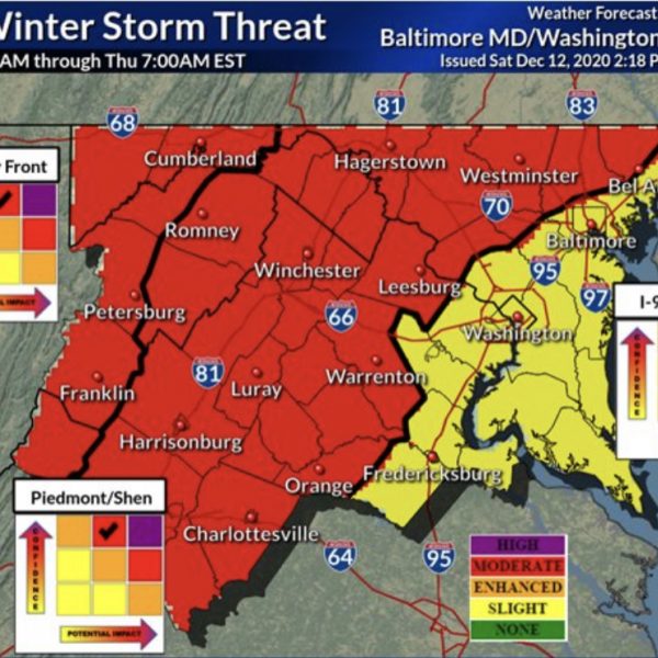
4pm UPDATE: The National Weather Service has increased the level of confidence and possible impact from the “enhanced” to “moderate” zone, which is one step below the most severe– “high” for half of MoCo.

Significant Snow Storm Possible This Wednesday (12/16)

It’s very easy to get excited for digital snow. Digital snow is the snow we’re “supposed” to get when we are days away from the actual storm possibility.

Right now, I’m excited for digital snow. We are inside of 5 days and models are agreeing on what looks like a significant storm heading our way this Wednesday.

We have a chance for some light snow on Monday, but that won’t be as impactful as the Wednesday storm.

I would be more confident if things still looked this way inside of 3 days, but for us to have this kind of opportunity in mid-December is amazing for snow lovers (especially in a season where experts predicted low snow totals for the winter).

Things can change, but as of now here is how things look:

The UKMET (UK model) is currently showing about 6”-9” for MoCo.

The GFS (American model) has shown a significant storm for three runs in a row with totals at or above the 1 foot mark for almost all of MoCo.

The Euro (European model who many trust the most) just had a run that showed the potential for some mixing with sleet/rain the closer you get to DC, but still shows some relatively high totals (a foot or more for much of MoCo). The timing now looks like a Wednesday night into Thursday situation, but we have to keep an eye on that warm air.

Right now we are still in a position where this thing moves a little bit in one direction and we miss out on big snow totals or moves a little bit in the other direction and we receive over a foot of snow.

What does this mean for virtual school? I’m not sure, honestly. I don’t think a school system would cancel virtual school, but if this ends up becoming a warning level event…it may definitely be disruptive.

We’ll keep an eye on this one and provide daily updates for you.

Featured image courtesy of the National Weather Service.

0 Comments
×

Subscribe to our mailing list