Wednesday Storm Update (Tuesday Afternoon Update)

You called it! Something we’re all used to in our area has occurred– Winter Disappointment.

The storm that once had the potential to bring double digit snow totals to our area now doesn’t look nearly as strong.

4:55pm UPDATE: Winter Storm Warning for N/NW MoCo tomorrow. Winter Weather Advisory for C/S/SE MoCo

Total snow and sleet accumulations of 3 to 6 inches and ice accumulations of up to one tenth of an inch in the warning area and 1 to 3 inches and ice accumulations of around one tenth of
an inch in the advisory area.

The National Weather Service, along with most local networks, have dropped their projected snow totals for much of the area.
Here’s how things look now:

• Parts of MoCo closer to DC (Bethesda/Silver Spring) will get anywhere between a coating to two inches of snow.

• As you move up towards Rockville, you get to 2-3”

• Gaithersburg/Germantown/Olney is looking like 3-5”

• Clarksburg/Damascus looks to be in the 6-8” range

This is definitely not a non-event, it’s just not what many snow lovers were hoping for.

We’ll keep an eye on things in case there are further changes prior to the start tomorrow morning and will have an update for you tonight.


0 Comments

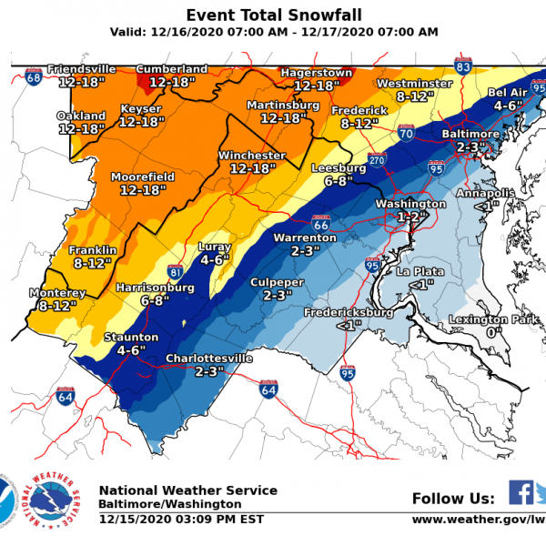
Wednesday, 12/16 Storm (Tuesday Morning Update)

A Winter Storm Watch remains in effect for our area as we are now one day away from the wintry weather.

The local news outlets seem to be agreeing on a general 1-3” for S/SE MoCo and 3-6” for N/NW MoCo. WUSA9 has a little less, and NBC4 has a little more.

The National Weather Service (seen in our featured photo) still has higher totals as S/SE MoCo is at 4-6” and N/NW MoCo is at 8-12.”

Things should start off as light snow in the late morning hours before becoming heavier in the late afternoon. We will likely see ice mix in as we move into Wednesday evening and rain could start to creep up into S/SE MoCo on Wednesday night before everything switches back over to the icy mix and ends as snow.

As always, it’s about the rain/snow line. If temps are colder than forecasted we can see a “boom scenario” that could double projected snow totals. If temps are as advertised, we likely see the ranges most of the news stations are predicting, and if temps are warmer than expected, you cut those totals in half.

The short range models will be relevant today so we’ll have a couple updates for you as the storm approaches.

Here is what MCPS plans to do for inclement weather during virtual learning.

0 Comments

Montgomery County Public Schools have remained entirely virtual since the start of the school year. So what happens if it snows?

Fox 5 reported the following for Montgomery County:

”Unless there is a countywide power outage of sorts, the county anticipates following their normal virtual instructional schedules on days when it snows. They say they would need to revisit that once they start to bring groups of students back in the building.”

MCPS does have a plan to continue providing meals for students in need during the winter storm. They’ll be providing three days’ worth of meals will be served at meal sites on Tuesday, Dec. 15, to cover Dec. 15 – Dec. 17. Meal service will resume on Friday, Dec. 18.

A poll we started on our MoCoSnow Twitter account (@MCPSsnow) has led to mixed results on whether or not students should still have snow days during virtual learning.


0 Comments

The National Weather Services Releases First Snow Forecast for Wednesday, 12/16

The Winter Storm Watch has now been extended to include all of MoCo

In the National Weather Service’s first projected snowfall total map for the Wednesday storm, we see quite the gradient.

In areas closer to DC (Bethesda/Silver Spring), the NWS is going with about 3-4” with this map.

Areas in the middle, like Rockville and Gaithersburg are in the 6-8” range.

Poolesville, Germantown, and Clarksburg are in the 8-12” range, and Damascus leads the way in the 12-18” range.

Capital Weather Gang has the southern parts of MoCo in the 1-4” range, central MoCo at 4-7”, and upper MoCo at 6-12”+ (with boom and bust scenarios).

See what the local networks are calling for here.

0 Comments

It wouldn’t be the DMV without uncertainty about winter weather.

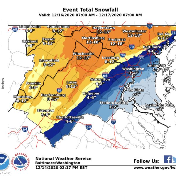
A winter storm watch was issued for the N/NW part of MoCo earlier this morning for the Wednesday storm. The major networks have released their second round of forecasted snow totals, but models are still all over the place.

Top left, WUSA9, is the most conservative of the bunch with this storm going with 1-3” for all of MoCo.

Fox5 has most of MoCo in the 3-6” range with the N/NW third of the county in the 6-12” range.

NBC4 has most of MoCo in the 4-8” range with the S/SE third of the county in the 1-4” range.

ABC7 has a range that is very similar to NBC4, with most of MoCo in the 4-8” range.

The models haven’t come together on a solution either.

The GFS has dropped its totals for MoCo to 2 inches for those closer to DC and up to 8 inches in parts of Upper MoCo.

The Euro is still showing high snow totals with a much wider range of 5 inches near DC and over a foot in parts of Upper MoCo.

We will continue to monitor this storm and see which direction it moves towards as we get within 48 hours.


0 Comments

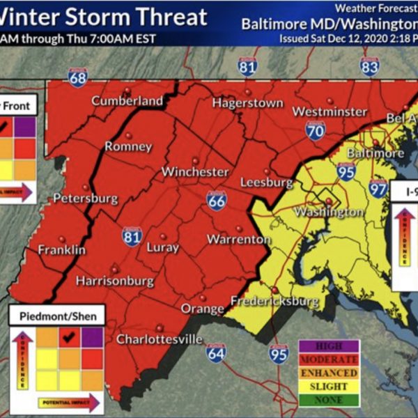
Significant Winter Storm Possible This Week (Sunday Afternoon Update)


As we approach the three day mark, it still looks like a significant winter storm is headed our way on Wednesday.


“I’ll believe it when I see it” is a common response for anyone who has experienced winter in our area, as things can change quickly and hopes are often dashed as the potential moves closer.


Let’s talk about tomorrow first (Monday). This storm will likely be rain for most of MoCo with the possibility of upper Montgomery County seeing some flakes and possible even a slushy inch. Don’t count on too much winter weather from this one.


Wednesday’s storm is the one we are keeping a close eye on and here’s where we stand right now:


The GFS (American model) has been hanging on to the idea of a major winter storm for our area for several runs now. Giving MoCo between 4 inches closer to DC and 9+ Inches for Upper MoCo.


The Canadian model, which always tends to show more snow than we end up getting has backed off the higher snow totals (like a 4”-6” situation).


The UKMET has also backed off the major snow storm and is showing a wide range in MoCo from 1” closer to DC to almost 6” in Upper MoCo


The Euro, the model most feel is the most reliable at this range, has just come in and is showing big time snow for MoCo with areas near DC getting around 8 inches and upper MoCo getting over a foot.


There are still a lot of moving parts to this so we’ll see which way we go in the coming runs. I would expect the major networks to start releasing their early forecasted snow totals tomorrow.


For now, I’d stay away from the weather apps because I feel like they throw out projected totals way too early.


We’ll continue to monitor and post updates as frequently as possible.


Featured photo courtesy of the National Weather Service
0 Comments

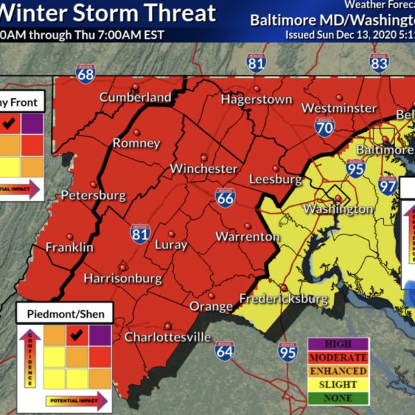
4pm UPDATE: The National Weather Service has increased the level of confidence and possible impact from the “enhanced” to “moderate” zone, which is one step below the most severe– “high” for half of MoCo.

Significant Snow Storm Possible This Wednesday (12/16)

It’s very easy to get excited for digital snow. Digital snow is the snow we’re “supposed” to get when we are days away from the actual storm possibility.

Right now, I’m excited for digital snow. We are inside of 5 days and models are agreeing on what looks like a significant storm heading our way this Wednesday.

We have a chance for some light snow on Monday, but that won’t be as impactful as the Wednesday storm.

I would be more confident if things still looked this way inside of 3 days, but for us to have this kind of opportunity in mid-December is amazing for snow lovers (especially in a season where experts predicted low snow totals for the winter).

Things can change, but as of now here is how things look:

The UKMET (UK model) is currently showing about 6”-9” for MoCo.

The GFS (American model) has shown a significant storm for three runs in a row with totals at or above the 1 foot mark for almost all of MoCo.

The Euro (European model who many trust the most) just had a run that showed the potential for some mixing with sleet/rain the closer you get to DC, but still shows some relatively high totals (a foot or more for much of MoCo). The timing now looks like a Wednesday night into Thursday situation, but we have to keep an eye on that warm air.

Right now we are still in a position where this thing moves a little bit in one direction and we miss out on big snow totals or moves a little bit in the other direction and we receive over a foot of snow.

What does this mean for virtual school? I’m not sure, honestly. I don’t think a school system would cancel virtual school, but if this ends up becoming a warning level event…it may definitely be disruptive.

We’ll keep an eye on this one and provide daily updates for you.

Featured image courtesy of the National Weather Service.

0 Comments
×

Subscribe to our mailing list