Temperatures will feel like mid-November to start the week with highs barely reaching the 50s today and tomorrow.
Mid-week will see a warm up as Wednesday is expected to make it to the mid 60s before Thursday’s climb into the low to mid 70s


Temperatures will feel like mid-November to start the week with highs barely reaching the 50s today and tomorrow.
Mid-week will see a warm up as Wednesday is expected to make it to the mid 60s before Thursday’s climb into the low to mid 70s
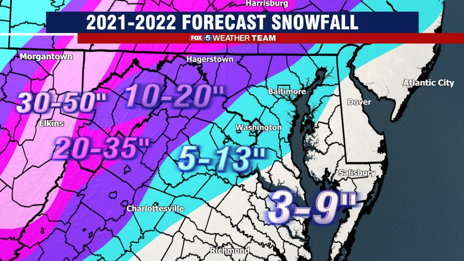
Fox 5 is the first of the major local networks to release a winter outlook and it may be a little disappointing for snow lovers.
Another “La Niña” is expected (like last year), which means the jet stream and severe weather are likely to be farther north, while weather is the south is warmer than usual. We usually have below average snowfall and above average temperatures during La Niña winters.

A Freeze Warning will be in effect for Northwest MoCo and a Frost Advisory will be in effect for Central and Southeast MoCo from 2am until 10am on Wednesday morning.
For the warning areas, (Germantown, Clarksburg, Damascus, Poolesville, etc.) sub-freezing temperatures as low as 29° can be expected.

Temperatures will drop a bit today, reaching the upper 50s, but the rest of the week will be the chilliest it has been since the first half of 2021.
Highs for the rest of the week will be in the lower 50s with lows in the low/mid 3s.
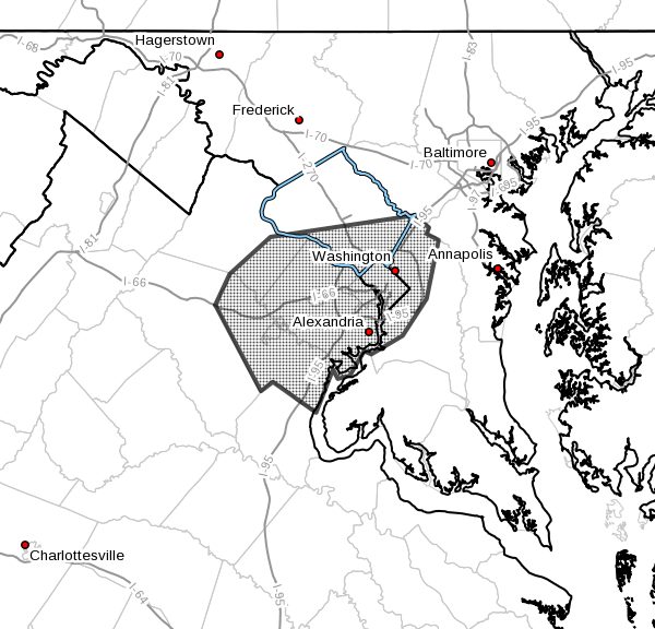
The Flood Watch that was in effect for Central and Southeast MoCo is now a Flood Warning. The warning goes into effect now until 6:30pm.
Per the National Weather Service:

A Flood Watch is in effect for Central and Southeast Montgomery from 10am Friday morning until 6pm Friday evening.
Due to the rain and potential for flooding, Meadowbrook Local Park in Chevy Chase is closed. Beach Drive is also closed from Knowles in Kensington down to the D.C. line.

Areal Flood Watch in effect for Central and Southeast Montgomery from 10am Friday morning until 6pm Friday evening.
It is advised to monitor later forecasts and be alert for possible Flood Warnings. Those living in areas prone to flooding should be prepared to take action should flooding develop.
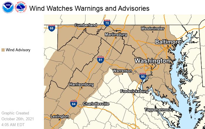
A Wind Advisory will be in effect from noon today until midnight in Montgomery County
Per the National Weather Service:

Summer is coming to an end tomorrow (Tuesday, 9/21) and though it may feel warmer a few days, it currently looks like highs will remain below 80° for the foreseeable future.
Tems will be in the upper 70s for the last two days of summer (Monday and Tuesday), with an increasing chance of rain as we get into the middle part of the week.

The Farmers’ Almanac has released its 2021-2022 extended winter outlook.
MoCo and almost all of Maryland seem to fall under the “Typical winter chill, Stormy January, Tranquil February” category. Just to our south is the “Quite chilly, mixed bag of precipitation” category that we may be a little more used to in recent years.

MoCo Activates Extreme Heat Plan Until 7pm Today