A Winter Weather Advisory is now in effect for all of MoCo from 7am until 3pm on Saturday.

Per the National Weather Service:

* WHAT…Snow expected. Total snow accumulations of 2 to 4 inches. Northwest winds will gust around 45 to 55 mph.

* WHERE…Portions of central and northeastern Maryland, northern and central Virginia, and the District of Columbia, including most of the DC and Baltimore metros.

* WHEN…From 7 AM to 3 PM EST Saturday. Rain will change to snow between 7 and 9 AM early Saturday. The steadiest snow will be through Saturday morning.

* IMPACTS…Plan on slippery road conditions. Gusty winds could bring down tree branches.

* ADDITIONAL DETAILS…Visibility may be reduced to below one- quarter mile at times. Brief near blizzard conditions are possible between 8 and 11 AM.

PRECAUTIONARY/PREPAREDNESS ACTIONS… Slow down and use caution while traveling. When venturing outside, watch your first few steps taken on steps, sidewalks, and driveways, which could be icy and slippery, increasing your risk of a fall and injury.

A Wind Advisory is also in effect from 6am Saturday until 1am Sunday

* WHAT…Northwest winds 25 to 35 mph with gusts up to 55 mph.

* WHERE…Portions of northern and central Maryland, northern Virginia, and the District of Columbia including the DC and Baltimore metro areas.

* WHEN…From 6 AM Saturday to 1 AM EST Sunday.

* IMPACTS…Gusty winds could blow around unsecured objects. Tree limbs could be blown down. Several power outages may result.

* ADDITIONAL DETAILS…A few gusts to around 60 mph are possible. Strong winds may persist into early Sunday morning. PRECAUTIONARY/PREPAREDNESS ACTIONS… Use extra caution when driving, especially if operating a high profile vehicle. Secure outdoor objects. Prepare for power outages.

We’ll have an update for you with additional maps tonight.

0 Comments

This morning we let you know that a period of snow is possible on Saturday following rainfall early in the day. Temps will drop into the 30s on Saturday afternoon and eventually the upper 20s, which would allow for snow in the afternoon.

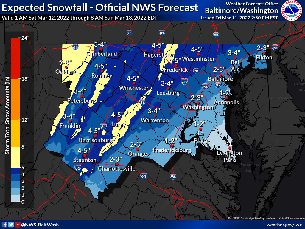
The evening update from the National Weather Service had almost all of MoCo in the 1 inch range with Damascus in the 1-2″ range.

The latest update from 7:12pm has half of MoCo in the 1-2″ range and the other half in the 3-4″ range. Things can still change and we will keep you updated throughout the day tomorrow.

Below you’ll see the latest ‘Forecaster’s Discussion’ per the NWS, which hasn’t changed form earlier today:

Precipitation will rapidly transition over to snow behind the system`s cold front. When this will happen in any given spot will highly depend on the system`s ultimate track. Guidance today has trended further southeast with the track of the low, which lends itself to a cooler solution.

“As a result, the expected and high end totals have been upped across the area. That being said, considerable uncertainty still remains, and we would like to see multiple runs of the same trend before confidence increases.”

0 Comments

Temperatures are expected to reach the low 50s today, but before we get there we’ll have to deal with some patchy fog and cold temperatures this morning that could cause a few slick spots. Below you”ll see an update from the National Weather Service:

Patches of dense fog has developed east of the Blue Ridge Mountains early this morning. With temperatures near or below freezing, there may be a few slippery spots during this time. Reduce speed and leave extra travel time and following distance. Be alert for slippery spots, and avoid braking or turning suddenly.

A period of snow is also possible on Saturday following rainfall early in the day. Temps will drop into the 30s on Saturday afternoon and eventually the 20s. If they drop soon enough, we’ll likely see the rain change to snow before the system heads out. As you’ll be able to read in the NWS ‘forecaster discussion’ below, it’s still unclear as to how much precipitation will be left by the time the cold air comes in.

Something to keep an eye on in case you have Saturday plans.

National Weather Service Forecaster’s Discussion:

Temperatures in the 40s and 50s ahead of the front will fall rapidly into the 20s and 30s behind the front Saturday afternoon (teens and single digits along the ridge tops). The potent upper-level trough will pass through the area behind the cold front Saturday afternoon/early evening. Given the strong dynamics with the upper-level trough, this does cause an anafrontal setup, where a period of precipitation is expected to occur on the cold side of the boundary.

Therefore, rain is likely to end as a period of snow for most areas. There is still some uncertainty as to how much precipitation will be left by the time the cold air arrives, but it does appear increasingly likely that there will be accumulating snow in the farther northern and western suburbs of Washington/Baltimore toward the Allegheny Highlands. The farther west you go, the higher the confidence is and that`s because the cold air will arrive sooner, and those areas are in a more favorable location given the synoptics (left exit of upper-level jet and just northwest of the 850mb lows track).

0 Comments

We are coming off of the warmest warmest couple days we’ve had in a while, but temperatures will be significantly cooler today with highs around 50 and even colder tomorrow with highs around 40.

You may have seen your weather app display a snowflake or let you know that some winter weather is possible tonight into tomorrow.

A period of rain and snow is likely early Wednesday morning. Temperatures have been warm and the ground will likely be too warm for anything to stick, but some snow is possible the further north/west you go. As you can see in the National Weather Service map below, the expected snowfall is less than an inch, with none expected in central and SE MoCo.

The high end amount shows half an inch to an inch and a half, depending on where you’re at in the county. Keep in mind that if this were to happen, it would likely only stick on grassy areas.

The probability of us getting more than in inch is about 2-20%, depending on your location in the county, per the map below.

This is less of a threat when it comes to closing anything down and more of a reminder that it’s still technically winter.A wintry mix is also possible for Friday into Saturday, but could also just be rain. We’ll monitor that one and have an update on this one later tonight.

0 Comments

There will be a high wind advisory in effect for MoCo from 11am Monday until 1am Tuesday.

Temperatures will likely reach the upper 70s, what a breezy start. Showers and possibly a thunderstorm are in the forecast, mainly after 4pm. Some storms could be severe, with damaging winds.  Winds could gust as high as 46 mph. Chance of precipitation is ~80%. Rainfall amounts between a tenth and quarter of an inch, except higher amounts possible in thunderstorms.

Per the National Weather Service (Wind Advisory):

* WHAT…Southwest winds 15 to 25 mph with gusts up to 50 mph expected shifting to northwest this evening.

* WHERE…Portions of The District of Columbia, central, north central, northeast, northern and southern Maryland and central, northern and northwest Virginia.

* WHEN…From 11 AM this morning to 1 AM EST Tuesday.

* IMPACTS…Gusty winds could blow around unsecured objects. Tree limbs could be blown down and a few power outages may result.

PRECAUTIONARY/PREPAREDNESS ACTIONS… Use extra caution when driving, especially if operating a high profile vehicle. Secure outdoor objects.

0 Comments

A Winter Weather Advisory remains in effect for MoCo, until 7am in Central and Southeast MoCo and until 10am in Northwest MoCo.

The advisory is calling for about a tenth of an inch of ice for Northwest MoCo and up to a tenth of an inch for Central and Southeast MoCo.

Currently temperatures are hovering around the freezing mark with some freezing drizzle/rain falling, which could make for slick conditions, but as you see in the tweet below from the National Weather Service, temperatures should slowly rise above freezing overnight.

By the time the morning commute gets started, most roads should just be wet, but there could still be some slick areas the further north you go.

The most recent map from the NWS is from 5:09pm today and is pretty similar to the maps from the last 24 hours showing very light ice across the board for MoCo.

Pencil Prediction for Friday, 2/25/22: 1.5 Pencils

While there’s a chance temperatures stay at or below freezing and things are a lot slicker than expected during the morning commute, right now it doesn’t look very likely.

0 Comments

The Winter Weather Advisory issued early this morning remains in effect from 7pm tonight, but it was recently extended until 10am for Northwest MoCo.

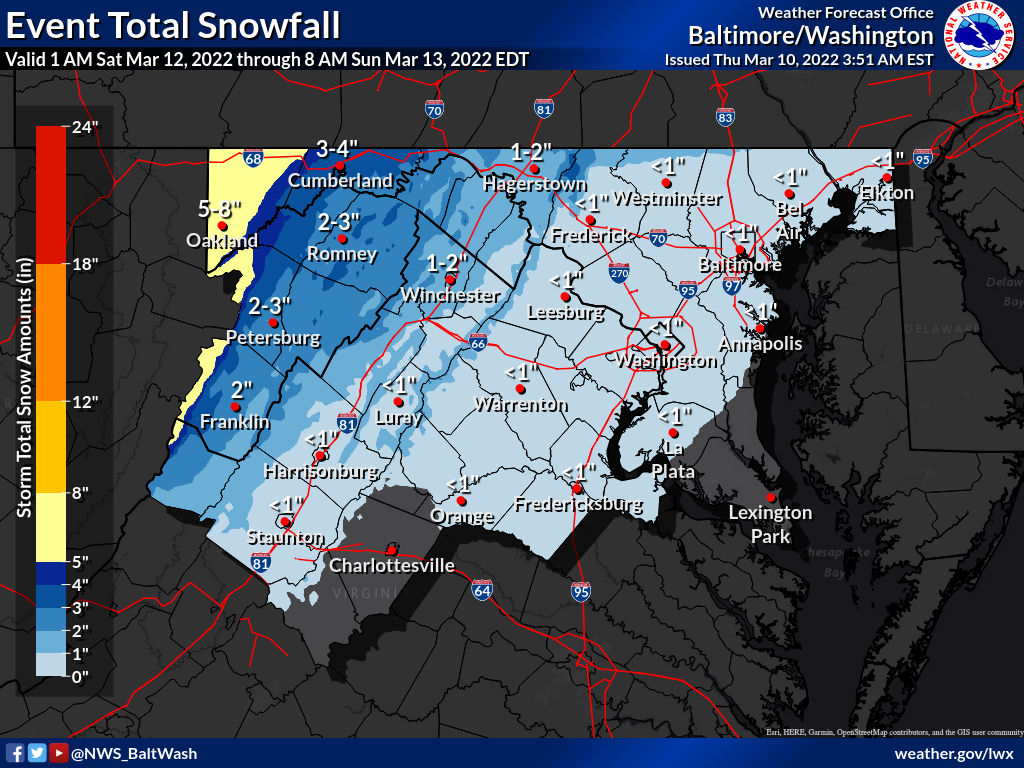
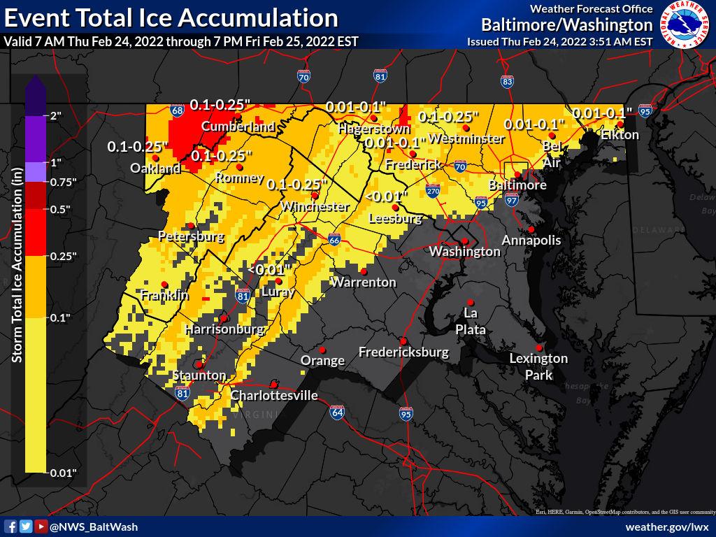
The featured photo shows the latest map from the National Weather Service, which hasn’t been updated since 3:51am this morning.

Below you’ll see what the advisory consists of for Northwest MoCo, per the National Weather Service:

* WHAT…Mixed precipitation expected. Ice accumulations of
around one tenth of an inch, with locally two tenths of an
inch in the higher elevations. Snow and sleet accumulations
less than a half inch are also possible.

* WHERE…Portions of central, north central and northern
Maryland, northern and northwest Virginia and eastern and
panhandle West Virginia.

* WHEN…Until 10 AM EST Friday.

* IMPACTS…Plan on slippery road conditions. The hazardous
conditions could impact the morning or evening commute.

* ADDITIONAL DETAILS…Light mixed precipitation will occur at times today, but a prolonged period of freezing rain will lead to greater impacts tonight into Friday morning.

PRECAUTIONARY/PREPAREDNESS ACTIONS…

Slow down and use caution while traveling.

When venturing outside, watch your first few steps taken on
steps, sidewalks, and driveways, which could be icy and slippery, increasing your risk of a fall and injury.

There are slight differences for Central/SE MoCo, with a little less icing/precipitation expected. That advisory can be seen below:

* WHAT…Mixed precipitation expected. Ice accumulations of up to one tenth of an inch. Sleet accumulations less than half an inch.

* WHERE…Portions of central, northeast and northern Maryland and northern and northwest Virginia.

* WHEN…From 7 PM this evening to 7 AM EST Friday.

* IMPACTS…Plan on slippery road conditions. The hazardous
conditions could impact the morning or evening commute.

* ADDITIONAL DETAILS…Light mixed precipitation may occur at times today, but the greater risk for hazardous travel will come from freezing rain tonight.

PRECAUTIONARY/PREPAREDNESS ACTIONS…

Slow down and use caution while traveling.

When venturing outside, watch your first few steps taken on
steps, sidewalks, and driveways, which could be icy and slippery, increasing your risk of a fall and injury.

We will continue to update throughout the day with a Pencil Prediction coming tonight.


0 Comments

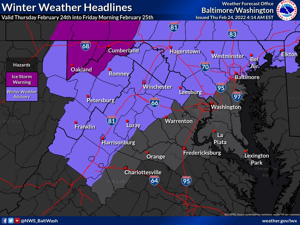
A Winter Weather Advisory is in effect this evening (Thursday, 2/24) at 7pm until tomorrow morning (Friday, 2/25) at 7am.

Per the National Weather Service:

WINTER WEATHER ADVISORY IN EFFECT FROM 7 PM THIS EVENING TO
7 AM EST FRIDAY…

* WHAT…Mixed precipitation expected. Ice accumulations of up to one tenth of an inch. Sleet accumulations less than half an inch.

* WHERE…Portions of central, northeast and northern Maryland and northern and northwest Virginia.

* WHEN…From 7 PM this evening to 7 AM EST Friday.

* IMPACTS…Plan on slippery road conditions. The hazardous
conditions could impact the evening and morning commutes.

* ADDITIONAL DETAILS…Light mixed precipitation may occur at times today, but the greater risk for hazardous travel will come from freezing rain tonight.

PRECAUTIONARY/PREPAREDNESS ACTIONS…

Slow down and use caution while traveling.

When venturing outside, watch your first few steps taken on
steps, sidewalks, and driveways, which could be icy and slippery, increasing your risk of a fall and injury.

We’ll continue to update throughout the day.

0 Comments

Today we enjoyed temperatures in the upper 60s and lower 70s, giving the area a taste of spring. Temperatures are expected to crash overnight, dropping to/around the freezing mark mid-morning Thursday morning. Highs tomorrow will likely be around 35 degrees with temperatures hovering around freezing again Thursday night when the precipitation begins and go back up to about 35 degrees in the morning. Right now, temperatures don’t support much ice, but it’s still possible things are a little cooler than expected.

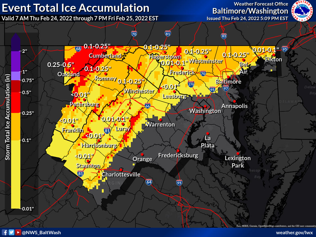
The most recent map from the National Weather Service, seen in our featured photo, shows almost all of MoCo getting a trace of ice with a sprinkle of northern areas getting up to a tenth of an inch.

Though temperatures could reach or even go below freezing, the ground will struggle to get cold enough to support much ice. Significant icing has a better chance of occurring the further north you go, but we’ll continue to monitor and have an update tomorrow morning.

Per the National Weather Service:

Arctic high pressure will allow for much colder air to build in ahead of the disturbance tomorrow but there continues to be a battle thermally for how p-types are going to be realized. For now, the most likely scenario as of the latest guidance would be for an initial period of rain/snow/sleet mix when temperatures are hovering at or just slightly below freezing. With the CAD wedge in place, it will be difficult to pinpoint the gradient of 0C and colder temps for the day on Thursday and into Friday.

Temperatures off the surface and further up are expected to warm up a bit during the day and will therefore start to introduce freezing rain potential for portions of the area, particularly north-west of the DC metro area. Guidance continues to be in a bit of disagreement with respect to temperatures and freezing rain accumulations. NAM/NAMnest/HRW suite are all much colder than other guidance and have been showing a cold bias this winter so inclination at this time is to gear towards a bit warmer solution with respect to this event. Canadian/GFS/ECMWF have a more climatological approach to the colder temperatures and the ice accumulation.

It will be interesting to see how temperatures and dew points react tonight and into Thursday morning to account for the potential shift in higher ice accumulation potential. For now, overall ice accumulations looks to be most significant across eastern Garrett, western Allegany and western Mineral counties. Ice accumulations of a quarter of an inch to three tenths of an inch are possible for those areas, yielding a Winter Storm Watch.

Elsewhere, accumulations of less than a quarter of an inch are expected north and west of DC, with higher amounts particularly in and around the Mason-Dixon line. Guidance has continued to have a northern shift in the higher amounts in terms of QPF and ice accumulation well into PA. Conditions should begin to improve by late Thursday night (southwestern areas) to late Friday morning (NE MD). Continue to visit weather.gov/lwx/winter for the latest winter forecast. Behind the disturbance, gusty winds will build in on Friday. These gusty northwest winds may be strong enough to yield a Wind Advisory but confidence is low at this time. Upslope snow may be possible for the Allegheny Front Friday night into Saturday morning with lingering low-level moisture coupled with a colder airmass.

0 Comments

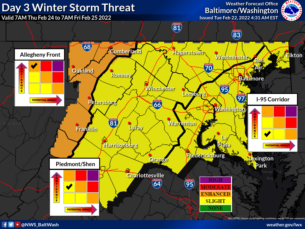
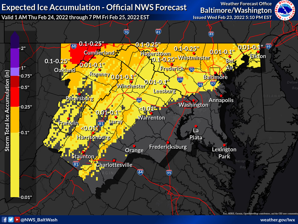
The National Weather Service has Montgomery County in the “Slight Winter Storm Threat” category for potential winter weather Thursday into Friday.

As of now, not much is expected for Montgomery County, with the threat of ice accumulation staying north for the most part. As you can see in the map below, some of the yellow goes into MoCo with Damascus possible having to deal with very light ice (one hundredth of an inch).

Some models have us getting a little bit ice while others have us getting nothing at all.  It’s worth keeping an eye on, but not something to worry about yet.

Forecaster’s Discussion from the National Weather Service can be seen below:

The forecast becomes rather tricky in the details
advancing forward through Thursday as light precipitation
overspreads the area. There is not a strong models signal for
widespread subfreezing temperatures, however dew points will
drop into the teens/lower 20s behind the front. This sets the
stage for potential light wintry mix...possibly a bit of snow
and sleet at the start, but more of a freezing rain concern for
any areas that are below freezing (or end up there due to
wetbulb processes). The complex interaction between temperatures
and precipitation during this first round will set the stage
for additional freezing rain Thursday night as low pressure
approaches the Appalachians. The highest precipitation amounts
are currently forecast near and north of the Pennsylvania
border. This also happens to be where temperatures are most
likely to be near the freezing mark. The current forecast
acknowledges the potential for cold air damming to work in favor
of wintry precipitation in climatologically favored areas and
temperatures are below blended guidance. However, there could be
a more widespread light icing threat, at least for a time. Stay
tuned to the latest forecast.
2 Comment

Snow totals are in from across the county after this morning’s light snow that caused minimal disruption across the area. The forecast for this storm was pretty accurate, as temperatures dropped overnight bringing light snow into the area for approximately 1-2” across the board with some areas a little higher.

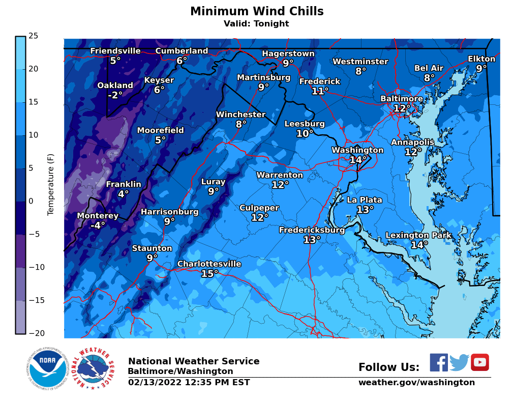
The totals below come from the National Weather Service from various times throughout the morning and afternoon. Wind chills tonight will be in the teens.

Note: Not all Montgomery County areas are included in the report below.

Damascus 3 SSW 2.1 955 AM 2/13 Co-Op Observer

Damascus 1 S 2.0 737 AM 2/13 Trained Spotter

Clarksburg 1 SSE 1.5 1230 PM 2/13 Trained Spotter Laytonsville 5 NNW 1.5 900 AM 2/13 CoCoRaHS

Damascus 1 SE 1.5 930 AM 2/13 Trained Spotter

Germantown 2 WSW 1.5 1130 AM 2/13 Trained Spotter Germantown 5 NNE 1.4 800 AM 2/13 CoCoRaHS

Poolesville SE 1.3 800 AM 2/13 CoCoRaHS

Montgomery Village 1 1.2 630 AM 2/13 CoCoRaHS

Colesville 2 W 1.1 700 AM 2/13 CoCoRaHS

Gaithersburg 3 NE 1.1 700 AM 2/13 CoCoRaHS

North Potomac 4 N 1.1 700 AM 2/13 CoCoRaHS

Norbeck 1 ESE 0.9 700 AM 2/13 CoCoRaHS

Potomac 1 NNW 0.8 700 AM 2/13 CoCoRaHS

Olney 1 ENE 0.8 640 AM 2/13 CoCoRaHS

Rossmoor 1 ESE 0.8 700 AM 2/13 CoCoRaHS

Rockville 3 E 0.6 615 AM 2/13 CoCoRaHS

Colesville 0.5 840 AM 2/13 Trained Spotter

White Oak 1 N 0.5 700 AM 2/13 CoCoRaHS

Silver Spring 6 NNE 0.2 440 AM 2/13 CoCoRaHS

0 Comments
×

Subscribe to our mailing list