MoCoSnow

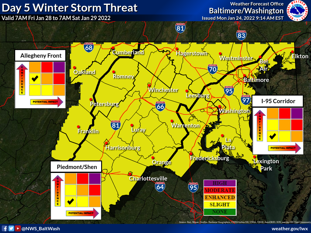
We remain in the “slight winter storm” threat category for potential winter weather this Friday into Saturday, according to the National Weather Service.

As we mentioned in yesterday’s update, this thing can go either way…and it already has. The GFS showed a major storm, took it away, brought it back, took it away (late yesterday), and has kind of brought it back again this morning with the model output showing a general 2-4″ for our area. The Euro didn’t show much, then started bringing the storm our way, took it away, and brought it back overnight for a model output of a general 4-6″ for our area.


MoCoSnow

For the last few days we’ve been tracking a storm that’ll be headed up the coast Friday evening into Saturday.

Early on, the GFS had the coastal storm bringing snow our way, but eventually moved it out east, missing us with most of the moisture. Recent runs have tended west, putting us back into play for measurable snow. The Euro didn’t have this storm coming our way, but has also trended in the favor of snow lovers, though not as much as the GFS.


MoCoSnow

A Winter Weather Advisory remains in effect for us tomorrow morning. From 4am in Upper MoCo and 6am in C/SW MoCo until 11am.

The National Weather Service has once again slightly increased its latest maps. About two thirds of MoCo is in the 2-3” range with a third in the 1-2” range. The “reasonable worst case scenario” map now shows up to 4 inches possible.


MoCoSnow

A winter weather advisory has been issued for MoCo starting 6am Thursday morning and going until 1pm (4am until 1pm for Upper MoCo).

The latest National Weather Service maps show most of MoCo in the 1-2” range with the upper third of the county in the 2-3” range. The “reasonable worst case scenario” map shows 3 inches for the entire county.


MoCoSnow

The National Weather Service updated its maps overnight, increasing potential snow totals for most of the area.

Per the maps, all of MoCo is in the 1-2” range for snowfall tomorrow morning. The “reasonable worst case scenario” map is now at just about 2 inches so confidence is increasing for 1-2” all around.


MoCoSnow

Rain is expected to develop overnight and change to a very brief period of sleet before the changeover to snow around 5am on Thursday morning. It should snow for a few hours, leaving anywhere between a coating to 3 inches of snow.

In the latest maps from the National Weather Service, they are still expecting less than an inch for most of the area, but have raised the “reasonable worst case scenario” totals to 2-4 inches for MoCo.


MoCoSnow

More snow is possible this week as the GFS (North American model) and Euro (European model) are going head to head in their latest runs regarding potential snow on Saturday.

The National Weather Service has our area under the “Slight Winter Storm Threat” category for this upcoming Friday into Saturday (featured photo).


MoCoSnow

The National Weather Service has released snow totals from yesterday’s winter storm. These totals come from various times, so they may be different than what you experienced in the same area due to the changeover to sleet, freezing rain, and eventually rain.

Clarksburg came in with the highest total measuring at just under 4 inches.


View More Stories