
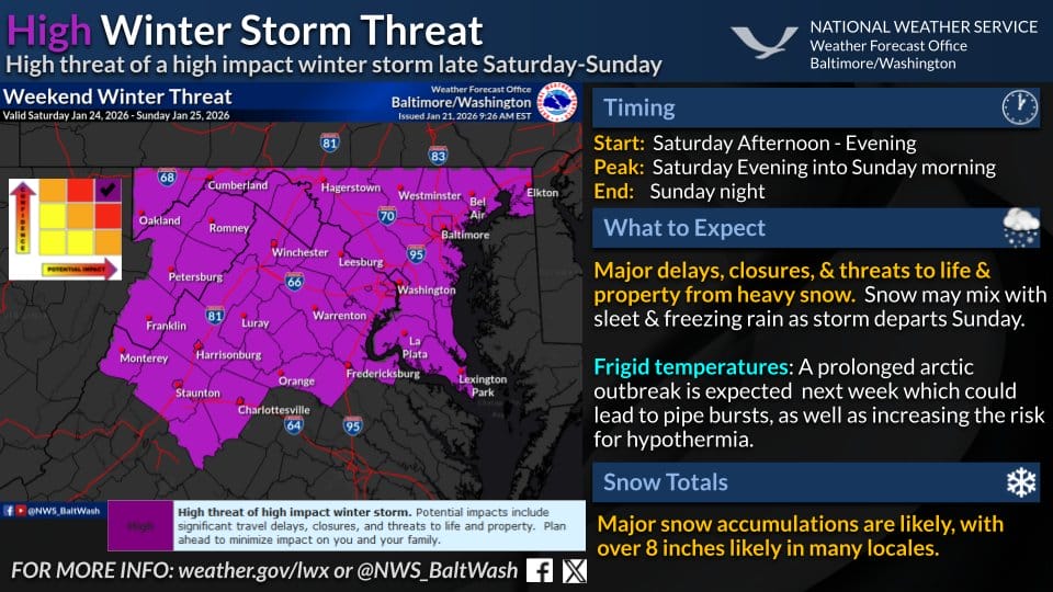
A major winter storm is expected to impact the region from Saturday afternoon through Sunday night, with National Weather Service (NWS) forecasters warning of a high impact event that could bring heavy snow, dangerous travel conditions, and extreme cold.
According to the National Weather Service, very cold Arctic air will already be in place as the storm arrives. That cold air will allow moisture moving in from the south to fall mainly as snow for much of the region. Snow is expected to begin Saturday afternoon, spreading from southwest to northeast, and continue through Sunday evening. The heaviest snowfall is most likely late Saturday night through much of Sunday.
Forecasters say there is now roughly a 50 percent chance that many areas could see a foot of snow or more. In northern and central parts of the region, snow is expected to stay mostly all snow. Farther south, especially south of the Capital Beltway and into parts of southern Maryland, there is a growing chance that snow could mix with sleet or freezing rain later Sunday, which could limit totals in those areas and increase the risk of icy conditions. The chance of mixing remains in our area following a hard thump of snow.
Meteorologists emphasize that this is shaping up to be one of the more widespread and impactful snowstorms the region has seen in years. FOX5 meteorologist Mike Thomas notes that when all forecast models are averaged together, they point to about 10 to 11 inches of snow, with about three quarters of the models showing at least 8 inches. Around 40 percent of the models are still showing a foot or more of snow, which is considered very high confidence this far out. WUSA9 meteorologist Kaitlyn McGrath echoed that concern, saying there is currently about a 50 percent chance that the area sees more than 9 inches of snow.
Beyond the snow itself, officials are stressing the danger from the cold. Temperatures are expected to drop into the teens during the storm and plunge even lower once it ends late Sunday night. The prolonged cold could lead to risks of hypothermia, burst pipes, and potential power outages, especially if heavy snow and ice bring down tree limbs or power lines.
The National Weather Service warns that travel delays, closures, and dangerous conditions are likely and encourages residents to prepare now. If forecast trends continue, this storm could rank among the region’s most significant winter events of the past decade.
