
This weekend’s winter storm is shaping up to be a significant system for parts of the East Coast, but at this point, it is likely to remain just far enough offshore to limit impacts in central Maryland (including Montgomery County) and northern Virginia.
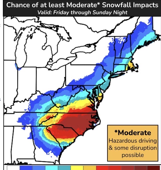
Forecast confidence continues to grow that a strong winter storm will develop along the Carolina coastline and rapidly intensify as it moves northeast, roughly parallel to the East Coast. Areas from southern Virginia into the Carolinas are currently the most likely to see meaningful snowfall and impacts. For our region, the current expectation is that the storm’s track stays far enough south and east that any precipitation that does fall would remain below advisory levels.
That said, this system is close enough that it cannot be ignored. Even small shifts north or west over the next several days could bring more noticeable impacts, especially given how tightly packed the expected snowfall gradient appears to be. In other words, locations could go from little or no snow to several inches over a relatively short distance if the storm track changes.
Per the National Weather Service forecaster’s discussion, the storm system is expected to form near the Carolina coast and strengthen quickly as it moves northeast along the shoreline. Most forecast models currently keep the storm just far enough offshore that our area would see little accumulation, if any. However, some model guidance still shows a realistic chance for a few inches of snow, even near major travel corridors like I-95. One of the key concerns is that snowfall amounts are expected to drop off very sharply on the northern edge of the storm. That means a small change in track could make a big difference in outcomes.
Right now, forecasters are most confident that the more significant impacts will remain to our south, particularly across southern Virginia and the Carolinas. While the potential exists for the storm to trend closer, there is an equal or even greater chance that it stays south of our area. Additional data over the next 24 to 36 hours will help clarify whether recent model fluctuations are meaningful or simply noise.
The bottom line is that this is a large and powerful storm, but at the moment it looks like our area may dodge the worst of it (or all of it). Because the system is close and the margin for error is small, it is worth keeping an eye on forecast updates over the next few days.
