
Forecasters are warning that a potentially significant severe weather event could impact the parts of Maryland and Virginia (including all of Montgomery County) Monday afternoon, raising questions about whether some school systems may adjust schedules or cancel after-school activities.
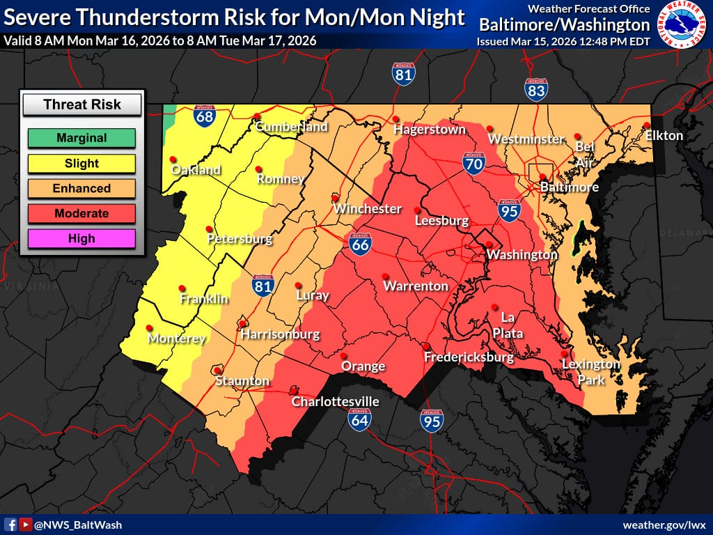
The National Weather Service (NWS) Storm Prediction Center has placed much of the region under a Moderate Risk (level 4 of 5) for severe thunderstorms on Monday, March 16, with the potential for damaging winds, tornadoes, lightning, and heavy rain.
NBC4 meteorologist Doug Kammerer said the risk level is unusual for the area. “Weather Alert!! The Storm Prediction Center now has our area under a Moderate risk for severe storms and Tornadoes! This is level 4 of 5! This is rare and has only happened a few times in the last 15-20 years. This means we will have a good chance to see Tornadoes in our area tomorrow afternoon and we will most likely be put under a Tornado watch by about 1pm tomorrow. The storms will move though between 2-6pm and into the metro between 3-5!”
The expected timing of the storms could overlap with the afternoon school dismissal period across the region. According to the Washington Post’s Capital Weather Gang, school officials will likely be closely monitoring the forecast before making any decisions. “Lots of questions about what schools will do Monday because If dangerous storm potential. We don’t know… but imagine some may cancel after school activities or even dismiss early,” the Capital Weather Gang wrote. “It’s tough because the exact timing is uncertain… don’t want dismissal when the storms are coming through. Models have shifted squall line somewhat later which is good because should give time for folks to get home but timing could still change. Schools will need to monitor forecasts and coordinate with NWS and their emergency management agencies on Monday.”
Meteorologists say the primary concern locally may be powerful straight line winds as a line of storms moves through the area later in the day. FOX5 meteorologist Mike Thomas said multiple forecast models show an active afternoon across the region. “All have an active afternoon in the DC region, as one would expect from our first Moderate Risk day in a few years,” Thomas said.
Thomas noted that the main threat around Washington will likely come from a squall line capable of producing damaging wind gusts. “Primary concern around the immediate DC area will be with the squall line later in the day. Likely in the general time frame of the evening commute. Strength of the low level jet suggests storms could mix down winds of 70-80mph+ at the surface, so straight line wind damage is the biggest threat here.”
While the highest tornado potential may stay to the south, Thomas said rotating storms or brief tornadoes cannot be ruled out locally. “That said, any storm that happens to fire ahead of the primary squall line will have the tendency to want to rotate… So wouldn’t rule out some warnings closer to home either. Embedded, brief tornadoes/gustnados embedded within the squall itself (‘kink in the line rotation’) will be a threat as well.”
Forecasters say storms could begin developing west of the region around midday before moving into the Washington metro area during the mid to late afternoon hours. Residents are encouraged to stay weather aware Monday afternoon, have multiple ways to receive warnings, and be prepared to take shelter quickly if severe weather develops.
