
WUSA9 has issued its first snowfall call ahead of a potentially major winter storm expected to impact the region this weekend, as confidence continues to grow in significant snow and ice across much of Maryland and Virginia.
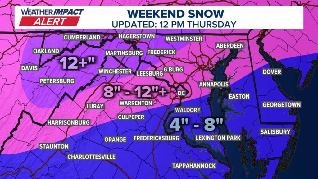
Meteorologist Kaitlyn McGrath shared her initial assessment, noting that areas that remain all snow the longest are likely to see the highest totals. She emphasized that even locations south of Washington, D.C. that may mix with sleet are still facing a high impact event. As of now, she expects much of southern Maryland to end up near the eight inch mark.
Her forecast aligns with a Winter Storm Watch now in effect for nearly all of Maryland and Virginia. Forecasters say a large area of precipitation will overrun Arctic air already in place across the Mid Atlantic, a setup that favors widespread and significant winter weather. Snow is expected to begin late Saturday and could become heavy at times, with the potential for a transition to sleet or freezing rain on Sunday, especially south of Highway 50 and near and east of Interstate 95.
The National Weather Service says there is a high likelihood of at least five inches of snow across the region, with the potential for totals exceeding ten inches in some areas. Ice accumulation is also possible, adding to the risk of dangerous travel conditions and potential power outages.
Beyond snow and ice, the cold will be a major concern. Very cold temperatures are expected to arrive Friday night and linger through the middle of next week. Sub zero wind chills are possible at times, increasing the risk for anyone spending extended time outdoors and complicating cleanup and recovery efforts after the storm.
Residents are encouraged to closely monitor forecast updates as the weekend approaches and begin preparing now for what could be a prolonged and high impact winter weather event.
