
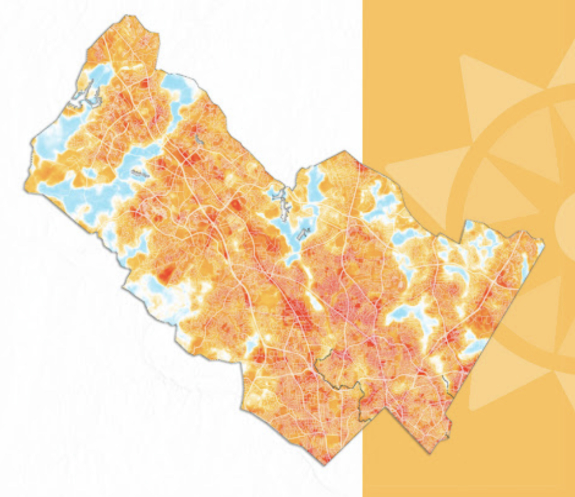
Per Montgomery County: The results of the 2022 Montgomery County “Urban Heat Island Mapping Campaign” document that neighborhoods with less green infrastructure and more concrete experienced temperatures up to 10 degrees higher than nearby cooler areas. The County’s Department of Environmental Protection (DEP) released the results of the campaign in partnership with the National Oceanic and Atmospheric Administration (NOAA) and Climate Adaptation Planning and Analyst (CAPA).
A StoryMap created by DEP provides a comprehensive overview of the campaign. Among its findings were that areas with low-income households and people of color have higher temperatures than other areas in Montgomery County due to a lack of green spaces and trees, indicating that extreme heat is a social justice issue.
The campaign brought together local organizations and volunteers to produce heat maps and generate creative and collaborative solutions for extreme heat in the area. The data will help Montgomery County identify areas where it can take action to protect vulnerable populations and build resilience against extreme heat risks.
The StoryMap provides an overview of the campaign’s methodology, results and solutions. The StoryMap highlights include the following:
- Areas with low-income households and people of color were found to have higher temperatures than other areas in Montgomery County, indicating that extreme heat is a social justice issue.
- Trees and green spaces play a crucial role in mitigating extreme heat, and the campaign identified areas with low tree canopy coverage that require additional green infrastructure.
- The campaign engaged local residents and organizations in the data collection process, providing an opportunity for community members to actively participate in identifying solutions to extreme heat risks.
“The findings of the 2022 Urban Heat Island Mapping Campaign underscore the importance of community engagement in addressing the effects of climate change,” said County Executive Marc Elrich. “By working together, Montgomery County and its partners are taking proactive steps to build resilience and protect vulnerable populations from extreme heat.”
The StoryMap includes background information on extreme heat, the campaign day, media attention, response, and solutions. It also details the next steps DEP is taking to mitigate, adapt and build resiliency against extreme heat in the County.
The StoryMap can be viewed at https://storymaps.arcgis.com/stories/389babe7ce654fdd87701488ae72e8b6.
In addition, CAPA has released a summary report of the campaign’s findings that can be accessed at https://osf.io/pk7uw?view_only=003a354126284c2298ec365424fac4b3.
For more information about Montgomery County’s efforts to address climate change, visit https://www.montgomerycountymd.gov/DEP/.
Recent Stories

Today in the Circuit Court for Montgomery County, MD, judge Jeanne Cho sentenced defendant, Tyrone Curtis, to life in prison suspend all but 15 years and five years of supervised…

The Quince Orchard Athletic Department has announced the hiring of Richard Tyler Jr. as its new Head Varsity Wrestling Coach. Rich Tyler is an accomplished athlete and coach with a distinguished…

Locally Crafted will reopen at its new location (9 Grand Corner Ave.) in Gaithersburg’s Rio Lakefront on Wednesday, May 1st. The store closed its previous storefront on December 24th, 2023….

Montgomery County Police has release surveillance images of a suspect wanted in connection to an assault and robbery that occurred last month in Wheaton.
FEST OF SPRING Caribbean Wine Food & Music Festival

Get ready to experience the vibrant colors, tantalizing flavors, and infectious rhythms of the Caribbean at the FEST OF SPRING Caribbean Wine Food & Music Festival! Hosted by RHU LLC, this exciting festival is set to take place on May 18, 2024, at the picturesque 16700 Barnesville Rd in Boyds, MD.
Step into a world where the Caribbean spirit comes alive! From 12:00 PM onwards, immerse yourself in a sensory journey that celebrates the unique culture, cuisine, and music of the Caribbean. Whether you're an African American, a Reggae or Soca music enthusiast, a wine lover, or part of the vibrant Caribbean diaspora, this festival promises to delight and captivate you in every way.
Let the enticing aromas of mouthwatering Caribbean dishes tantalize your taste buds. Feast on traditional delicacies prepared by expert chefs, showcasing the rich and diverse culinary heritage of the Caribbean. Indulge in flavorful jerk chicken, succulent seafood, and delectable plantain dishes that will transport you straight to the islands.
Accompanying the culinary extravaganza is a carefully curated selection of premium wines, ensuring the perfect pairing for your palate. Sip on fine wines from renowned vineyards, each sip a reflection of the Caribbean's vibrant spirit. Discover new flavors, expand your wine knowledge, and savor unforgettable moments with every glass.
As the sun sets, get ready to groove to the infectious rhythms of Caribbean music. Feel the pulsating beats of reggae, soca, dancehall, and calypso, moving your body to the lively melodies. Live performances by talented musicians and performers will keep the energy high, ensuring a night of unforgettable entertainment.
Don't miss this opportunity to embrace the Caribbean spirit and celebrate the arrival of spring in style! Tickets are available on AllEvents, so secure your spot today. Join us at the FEST OF SPRING Caribbean Wine Food & Music Festival, where cultures collide and unforgettable memories are made.
LIVE PERFORMANCES By: CULTURE Feat. Kenyatta Hill, EXCO LEVI, IMAGE BAND, RAS LIDJ REGG'GO with Special Guest SUGAR BEAR FROM E.U. & MORE! & MORE!
MUSIC By: DJ ABLAZE, DJ SMALLY & NAJ SUPREME
2 NIGHT Camping packages available: RV/CAMPER $200 | TENTS $150 Starting on Friday May 17 @ 5pm | 30 RV SPACES | 30+ TENT SPACES
KIDS 12 & UNDER FREE!!!