MoCoSnow

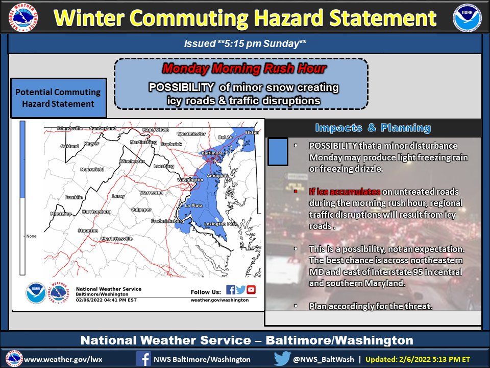
The ‘Special Weather Statement’ from earlier today has been update to no longer include C/SE MoCo. It now covers areas as close as Prince George’s County with potential for hazardous commuting conditions for the Monday morning commute.

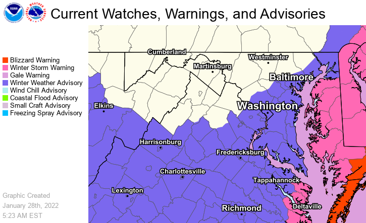
Per the National Weather Service for ‘Special Weather Statement’ areas (shown in featured photo):


MoCoSnow

The National Weather Service has released a ‘Special Weather Statement’ for the area, which includes Central/SE Montgomery County. The full statement can be seen below:

“There is a potential for hazardous commuting conditions for the Monday morning commute.


Education

Montgomery County Public Schools has released a survey about the possibility of virtual learning on days when schools are closed due to inclement weather. The survey must be completed by Monday, January 31 at noon.

Per the Maryland State Department of Education, all school systems are required to have at least 180 instructional days per year. With inclement weather, multiple school system closures may require adjustments to the school year calendar (e.g., extending the year, using other identified days). MCPS is planning for options that allow for virtual instruction on inclement weather closure days. While virtual instruction cannot replace time in the classroom, MCPS believes it is essential to continue to provide access to learning opportunities. Your feedback on this intent will help inform the district’s implementation plan.


MoCoSnow

A winter weather advisory is in now in effect for all of MoCo until 4am Saturday morning for C/SE MoCo and until 1am for NW MoCo.

MCPS UPDATE: MCPS Schools Close on Time; After-School and Evening Activities Canceled, Today, Jan. 28. Montgomery County Public Schools will close at the regularly scheduled time today. All after-school and evening school and community activities in school buildings are canceled. Childcare programs in school buildings may remain open as scheduled.


MoCoSnow

The most recent maps from the National Weather Service shows quite a difference from their “reasonable worst case scenario” to the “low end amount” showing just how much uncertainty there is with this storm.

With so much uncertainty, timing beyond “Friday into Saturday” will become a bit clearer tomorrow.


MoCoSnow

We remain in the “slight winter storm” threat category for potential winter weather this Friday into Saturday, according to the National Weather Service.

As we mentioned in yesterday’s update, this thing can go either way…and it already has. The GFS showed a major storm, took it away, brought it back, took it away (late yesterday), and has kind of brought it back again this morning with the model output showing a general 2-4″ for our area. The Euro didn’t show much, then started bringing the storm our way, took it away, and brought it back overnight for a model output of a general 4-6″ for our area.


MoCoSnow

For the last few days we’ve been tracking a storm that’ll be headed up the coast Friday evening into Saturday.

Early on, the GFS had the coastal storm bringing snow our way, but eventually moved it out east, missing us with most of the moisture. Recent runs have tended west, putting us back into play for measurable snow. The Euro didn’t have this storm coming our way, but has also trended in the favor of snow lovers, though not as much as the GFS.


View More Stories