
UPDATE: A Winter Storm Warning has now been issued for Montgomery County starting at 3am Thursday morning and lasting until 6am Friday morning.
National Weather Service Ups Snow Forecast in Wednesday Morning Update
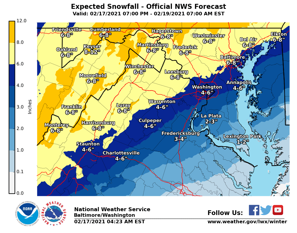
The National Weather Service has upped its snow totals for most of MoCo to 6-8” after overnight runs. Areas closer to DC remain in the 4-6” range. All of MoCo is also expected to see ice accumulation, as the county sits in the tenth to a quarter of an inch range in that map.


The networks remain fairly similar to where they were last night, with a few changes.


WUSA9 has a little over half of MoCo in the 6-9” range with the lower 40% (looks like Rockville and points south) in the 4-6” range.
ABC7 all of MoCo in the 3-6” range.
Fox5 also has all of MoCo in the 3-6” range.
NBC4 has most of MoCo in the 2-6” range, but areas like Clarksburg and Damascus in the 6-10” range.
The Washington Post’s Capital Weather Gang has Gaithersburg and all points north in the 3-6” range while Rockville and all points south are in the 2-4” range.

The boom and bust scenarios (25% chance for each) can get things as high as 10” for upper MoCo and as low as less than 2” for areas closer to DC.
Fox 5’s Mike Thomas showed that the overnight model ranges are kind of all over the place.


The maps above show snowfall totals from three different weather models.
The Euro (European model) showed most of MoCo in the 6-8” range.
The NAM, which is a higher resolution model that’s usually better with short term forecasts, showed a range of about 5-10” depending where you are in MoCo.
The GFS (American model) dropped the snow totals to 4-5” for most of MoCo.
The late morning and early afternoon runs will be helpful in determining the final calls for most area weather outlets prior to the short range models taking over.
So when will this start? Around 3-4am, give or take an hour. We should see a coating of snow by sunrise and it will continue to fall through the morning and into the afternoon. That’s when we could see sleet mixing in, which would cause even more problems for the roads.
There will be a pencil prediction coming later today for tomorrow. If you need a reminder on how snow days work virtually, check out the images below.
Updates coming throughout the day!

