
Friday Morning Snow Update for Sunday-Tuesday
For now, all models seem to be on board with a significant snow storm for our area.
The GFS (American model), Euro (European model), and UKMET (United Kingdom’s model) are all depicting what looks to be a disruptive snow storm.
Below you’ll see the GFS and Euro snowfall projections for Sunday and Monday, courtesy of Howard Bernstein of WUSA9.
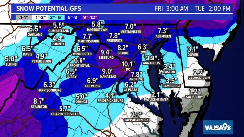
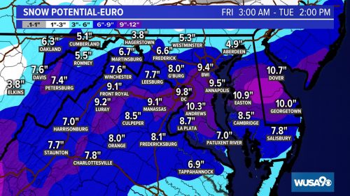 It’s interesting that both models are currently showing more snow for areas closer to DC than areas in upper MoCo, but both models are showing a range of about 8-10” for the county.
We are within 72 hours now, so we will likely start to see actual forecasts from our local news stations. Those will likely come out after today’s model runs this afternoon.
Our featured photo shows a conservative projection of 4-6” by the National Weather Service. If today’s runs stay the course, we expect to see their map change. Why are they going so conservative? Our best guess is that people take it a little better when more snow is added rather than when it is taken away…but there’s still time for this to change.
The way is stands now, snow is expected to enter our area Sunday morning. We should see some heavy bursts that drop a few inches (3-5” looks about right for now). There’s a chance things change over to sleet or freezing rain in the evening…even a chance of things stopping.
At that point we wait and see if the coastal low takes over and how fast it occurs. If it happens faster, then we will likely see snow start again and continue through Monday– giving us the higher totals.
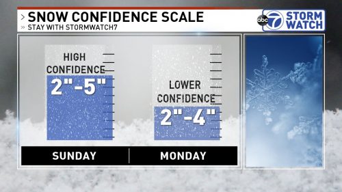
ABC 7’s graphic shows high confidence in that initial snowfall on Sunday and lower confidence in Monday’s potential.
We’ll have an update for you later this afternoon, likely with first calls from across the area.
Recent Stories
The Maryland State Police have released information regarding its participation in this Saturday’s National Drug Take Back Day.

Transportation Security Administration (TSA) officers have announced that it had intercepted its sixth gun at a security checkpoint so far this month.
Mayor Jud Ashman and members of the City Council hosted the 2024 State of the City address on Thursday, April 18, at Asbury Methodist Village.
Below is a list of businesses that have recently opened, closed, or are coming soon to Wheaton Mall at 11160 Veirs Mill Rd.
FEST OF SPRING Caribbean Wine Food & Music Festival

Get ready to experience the vibrant colors, tantalizing flavors, and infectious rhythms of the Caribbean at the FEST OF SPRING Caribbean Wine Food & Music Festival! Hosted by RHU LLC, this exciting festival is set to take place on May 18, 2024, at the picturesque 16700 Barnesville Rd in Boyds, MD.
Step into a world where the Caribbean spirit comes alive! From 12:00 PM onwards, immerse yourself in a sensory journey that celebrates the unique culture, cuisine, and music of the Caribbean. Whether you're an African American, a Reggae or Soca music enthusiast, a wine lover, or part of the vibrant Caribbean diaspora, this festival promises to delight and captivate you in every way.
Let the enticing aromas of mouthwatering Caribbean dishes tantalize your taste buds. Feast on traditional delicacies prepared by expert chefs, showcasing the rich and diverse culinary heritage of the Caribbean. Indulge in flavorful jerk chicken, succulent seafood, and delectable plantain dishes that will transport you straight to the islands.
Accompanying the culinary extravaganza is a carefully curated selection of premium wines, ensuring the perfect pairing for your palate. Sip on fine wines from renowned vineyards, each sip a reflection of the Caribbean's vibrant spirit. Discover new flavors, expand your wine knowledge, and savor unforgettable moments with every glass.
As the sun sets, get ready to groove to the infectious rhythms of Caribbean music. Feel the pulsating beats of reggae, soca, dancehall, and calypso, moving your body to the lively melodies. Live performances by talented musicians and performers will keep the energy high, ensuring a night of unforgettable entertainment.
Don't miss this opportunity to embrace the Caribbean spirit and celebrate the arrival of spring in style! Tickets are available on AllEvents, so secure your spot today. Join us at the FEST OF SPRING Caribbean Wine Food & Music Festival, where cultures collide and unforgettable memories are made.
LIVE PERFORMANCES By: CULTURE Feat. Kenyatta Hill, EXCO LEVI, IMAGE BAND, RAS LIDJ REGG'GO with Special Guest SUGAR BEAR FROM E.U. & MORE! & MORE!
MUSIC By: DJ ABLAZE, DJ SMALLY & NAJ SUPREME
2 NIGHT Camping packages available: RV/CAMPER $200 | TENTS $150 Starting on Friday May 17 @ 5pm | 30 RV SPACES | 30+ TENT SPACES
KIDS 12 & UNDER FREE!!!